VE MultiModal Model Project
A 2018 OregonDOT research project implemented by Liming Wang of Portland State University, updated VisionEval code (VE-RSPM) to enhance the mult-modal and land use attributes of the model. Current efforts are underway to implement this VE MultiModal (MM) modules in the VisionEval Suite of tools. This includes the following upgrades.
- Incorporation of land use built form "Ds" as variables in core VE methods. Previously such attribtues were limited largely to either a simplified mixed use measure and post-processing travel elasticities applied in VE-RPAT. The following built form attributes are included as zonal attributes and link to a household's home and work locations, as estimated with 2010 EPA Smart Location Database census block group data:
- Activity Density - Density of households and jobs per land area
- Diversity - Mix of households and jobs
- Destination Accessibility - Various measures of the accessibility of households and jobs for the bzone.
- Design - Walkable design (based on surrogate of pedestrian-oriented intersections per sq mile)
- Transit D - Transit frequency Level of service within an accessible distance of the bzone.
- Updated estimation of the core VisionEval TravelDemand package using 2009 NHTS (previously 2001 NHTS)
- Updated output travel metrics of all household modes (Vehicle, transit, bike, walk), incorporating the built form variables noted above. Both personal miles traveled (PMT) and trip lengths (via trip length frequency (TLF)) are estimated for each household in each modeled year.
The following figures highlight how the current VEHouseholdTravel model will be replaced with an "MM" version that incorporates the updated methods.
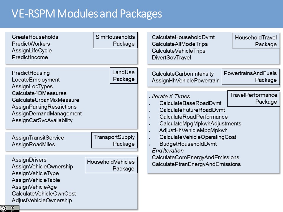
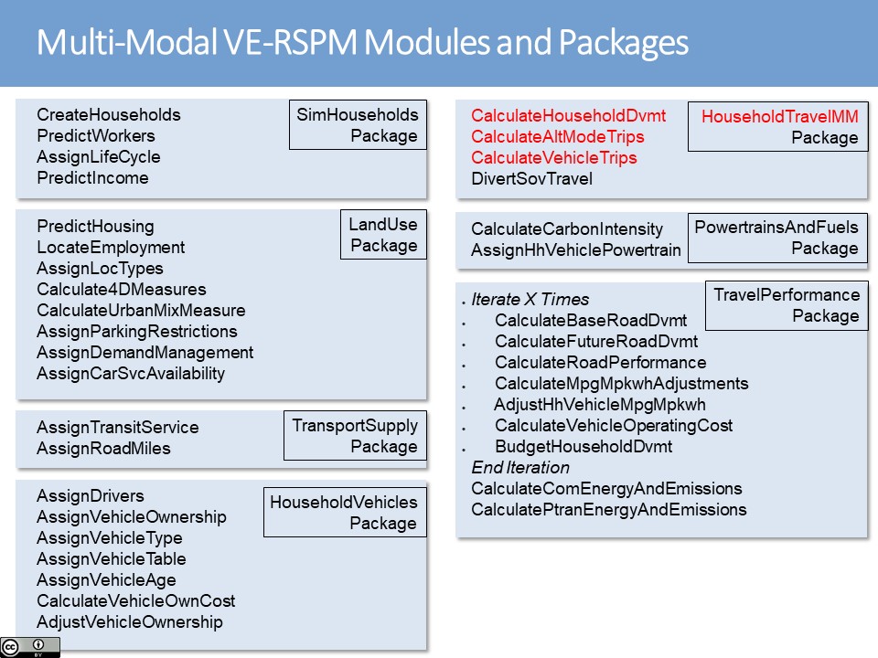
The VisionEval MM model will change both methods, inputs and outputs. Methods will reflect the new functional form of travel by mode, and new data (updated NHTS2009 and EPA SLD land use data), leading to different outcomes for household travel by mode.
Users will need to input significantly more detailed land use information at the most detailed Bzone level.
In early 2020 the VisionEval Pooled Fund Contractor was implementing the VE_MM model with the intention of it being tested by the end of 2020 in Atlanta using realistic land use data and alternative land use scenarios.
The original research project is documented by ODOT (here) and NITC (here). An article in the Nov 2018 Journal of Transportation and Land Use (JTLU Vol.11, No.1) documents the vehicle travel portion of the research.
This project also served as the pilot for a VisionEval Contributor Review Team process in 2017. Additional Documentation on the model shared in that review can be found here.
The following people were involved either in the original research project, the VE Contributor Review Team pilot, or in the current implementation in VE code repositories.
- Tony Knudson, ODOT Research Lead
- Liming Wang, PSU PI, Lead Academic Researcher
- Huajie Yang, Portland State University
- Brian Gregor, OSA
- Tara Weidner, ODOT
- Ben Stabler, RSG
- Daniel Flynn, Volpe
- Charles Baber, BMC (MdDOT rep)
- Jana Natarajan, WSDOT
- John Davies, FHWA-EERPAT
- Jeremy Raw, FHWA
- Brian Hurley, ODOT
- Chris Porter, Cambridge Systematics
- Patrick Hall, ARC
- Jana Natarajan, WSDOT
- Alex Bigazzi, UBC
- Kristin Tufte, PSU
- Josh Roll, ODOT
- Eric Pihl, FHWA
- Dan Frye, PSU(correct affiliation)
- Arash Asadabadi,WSP
- Rick Donnelly & Dave Ory???? **FIx LIST
Contact: Jeremy Raw, FHWA