Danger Areas
Pretty simple one this! ENR 5.1 contains all the coordinates for all the Danger Areas across the UK's airspace - not all will apply to the virtual world (I mean, do any of them?!) - but we like to make work for ourselves and do the sector file properly...
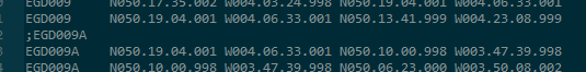
- The file is named according to the danger area it contains - if areas have multiple parts to them (a/b/c etc.), just one file for all is needed! Exemplar UK one... EG D009.txt
- Prefix each part to the danger area with a little comment of what it's called in the AIP ENR 5.1 doc - this time (confusingly) with no space between EG and the next letter. For example, ;EGD009
- Each line thereafter should repeat the name that is commented above, and the coordinates should start in column 12 - so for a danger area name that's 6 characters, you need 5 spaces after!
- Between different parts of the danger area, no extra blank lines please! Such is this seamless transition from EGD009 to EGD009A!

Any file (pick an 'EG ...' one) in the Danger Area folder should act as an example (these instructions were typed whilst looking at EG D009.txt). If it doesn't match the format described above... fix it please!!
The usual ES format here (DMS or something...) that looks like: N051.00.54.000 W000.27.00.000 Importantly, no colons between lat and long! Remember you can use this tool to convert from NATS AIP style coordinates to sector file style...