A proof-of-concept to use GoPro telemetry to generate a picture-in-picture map overlay for your GoPro videos.
Read this post for a bit more information about our thought processes in building this: https://www.trekview.org/blog/2022/overlay-gopro-telemetry-data-as-map-in-video
- First extract the telemetry file (as json) from your GoPro video using gopro-telemetry. Detailed instructions about how to do this can be found in this post.
- Install required packages
pip3 install -r requirements.txt - Fill in the
variables.txtwith your Mapbox API Key and username, and other variables if needed (seevariables.txtsection on this page.
python3 main.py -f TELEMETRY.json -i INPUT.mp4 -o OUT_DIRECTORY
-f: input telemetry json file (see prerequisites)-i: input video file you generated telemetry json from (and map should be overlaid on)-o: output directory for final video file with overlay
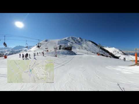
python3 main.py -f GX010044-gps-only.json -i GX010044.MP4 -o video-overlay/Output:
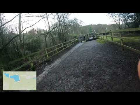
python3 main.py -f GS020176-gps-only.json -i GS020176.MP4 -o video-overlay/Output:
To run the script you need to set the required variables (and optional variables if you don't want to use defaults):
mapbox_key(required): your MapBox API key. You can get a MapBox API key here that will allow you 50,000 free static image lookups each month. Ensure your key has the following permissions when you create it;Styles:Tiles,Styles:Read,Styles:Write,Styles:List,Styles:Download,Styles:Protect,Fonts:Read,Datasets:Read,Vision:Read,Uploads:Read,Uploads:List,Uploads:Write,Tilesets:Read,Tilesets:ListandTilesets:Write- Default: ''
mapbox_username(required): you MapBox username/account name. You can see this under your account settings in MapBox- Default: ''
mapbox_base_style: Set your basemap style. Options include (but not limited to):mapbox/streets-v11,mapbox/outdoors-v11,mapbox/satellite-v9, andmapbox/satellite-streets-v11- Default:
mapbox/outdoors-v11
- Default:
mapbox_user_style: If you want to reuse a previous style you can pass it here like sotrekview/cl20cn42p009i15o97k316e8u(this variable is not needed 99% of the time).- Default: ''
mapbox_marker_label: You can add a label inside the marker. It can be a digit (0-9), a letter (a-z) or a Maki icon (without svg extension, i.e: circle). List of available icons.- Default: ''
mapbox_img_w: defines the width of the image for overlay as a ratio of input video (must result in a number between 1 and 1280). *0.2(20%) of input video width (for HERO) *0.1(10%) of input video width (for equirectangular)mapbox_img_h: defines the height of the image for overlay as a ratio of input video (must result in a number between 1 and 1280). *0.2(20%) of input video width (for HERO) *0.1(10%) of input video width (for equirectangular)mapbox_zoom_level: the zoom level for the map (recommended between 8-10). See MapBox docs for more. Between 0 and 22. In short, the higher the zoom number, the closer to the ground the zoom is.- Default:
10
- Default:
mapbox_line_colour_hex: the colour you want for the line passed as a 6 digit hex code * Default: #E48241mapbox_marker_colour_hex: the colour you want for the map point, passed as a 6 digit hex code (e.g.000000for black)- Default: #
000000
- Default: #
mapbox_line_width: the width in pixels for the linestring. * Default:1pxvideo_overlay_b_offset: defines the bottom offset of the image for overlay as a ratio of input video. Could be set manually to ratio value or px value (20px means 20 pixels off from bottom).- Default:
0.02(2%) video height (for HERO)0.3(30%) video height (for equirectangular)
- Default:
video_overlay_l_offset: defines the left offset of the image for overlay as a ratio of input video. Could be set manually to ratio value or px value (20px means 20 pixels off from left).- Default:
0.02(2%) video width (for HERO)0.3(30%) video height (for equirectangular)
- Default:
An example variables.txt with some custom values;
mapbox_key: YOUR_KEY
mapbox_username: YOUR_USER
mapbox_base_style: mapbox/outdoors-v11
mapbox_user_style:
mapbox_marker_label: circle
mapbox_zoom_level: 15
mapbox_line_colour_hex: ffffff
mapbox_marker_colour_hex: 3bb2d0
mapbox_line_width: 1
mapbox_img_w: 0.2
mapbox_img_h: 0.2
video_overlay_b_offset: 0.02
video_overlay_l_offset: 0.02
An example variables.txt with some custom values;
mapbox_key: YOUR_KEY
mapbox_username: YOUR_USER
mapbox_base_style: mapbox/outdoors-v11
mapbox_user_style:
mapbox_marker_label: circle
mapbox_zoom_level: 15
mapbox_line_colour_hex: ffffff
mapbox_marker_colour_hex: 3bb2d0
mapbox_line_width: 1
mapbox_img_w: 0.1
mapbox_img_h: 0.1
video_overlay_b_offset: 0.3
video_overlay_l_offset: 0.3
- Script detects if video is equirectangular or normal hero video using exiftool
- a
multiline.geojsonfile from all .json telemetry points - the
multiline.geojsonfile is uploaded as a new style to the specified MapBox account - the script used the new style which is used to generate a .jpg map images for each point in the
mapbox-images/directory. - The resulting images are wrapped up into a video containing map images at frame spacing rate defined in the telemetry json.
- The map video is overlaid using ffmpeg to the original video (based on default values or
variables.txtvalues) and all streams copied from original video (e.g. video, sound, and telemetry) to the new final video - exiftool is used to copy global metadata to the new final video
Community support available on Discord: https://discord.gg/ZVk7h9hCfw
The code of this site is licensed under a MIT License.