![]()
Haftungsausschluss: Dieses Repository und die zugehörige Datenbank befinden sich derzeit in einer Beta-Version. Einige Aspekte des Codes und der Daten können noch Fehler enthalten. Bitte kontaktieren Sie uns per E-Mail oder erstellen Sie ein Issue auf GitHub, wenn Sie einen Fehler entdecken.
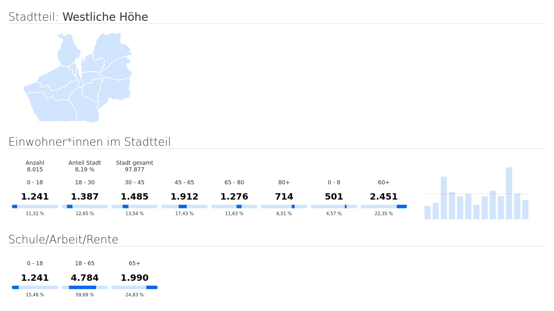
Der Sozialatlas der Stadt Flensburg wird bereits seit 2010 jährlich veröfentlicht. Dieser beinhaltet unter anderem Auswertungen zu folgenden Bereichen: Bevölkerung, Arbeitsmarkt und Beschäftigung, Wohnen, sozialen Sicherung sowie zu Hilfen zur Erziehung. Der Sozialatlas der Stadt Flensburg wird unter folgendem Link zum Download angeboten. Mit dem Sozialatlas 2022 liegt erstmals die Fortschreibung von Sozialstrukturdaten für die Stadt Flensburg und ihre 13 Stadtteile vor. Die Geodaten der einzelnen Stadtteile wurden freundlicherweise von der Stabsstelle Statistik der Stadt Flensburg zur Verfügung gestellt.
Der digitale Sozialatlas soll eine Grundlage für verschiedene Planungsaktivitäten der Stadt Flensburg und deren Einwohner:innen anbieten. Ziel ist die differenzierte Beobachtung von relevanten Indikatoren, die Aufschluss über die soziale Lage der Stadt und ihrer 13 Stadtteile geben. Bitte dazu auf den Umriss eines Stadtteils klicken, um die jeweiligen Details angezeigt zu bekommen. Dies ist ein erster Prototyp. Wir möchten diesen mit Filtermöglichkeiten ausbauen.
To setup the app, make sure to follow the steps to prepare the setup.
sudo apt install wget
sudo apt install git git-lfs
sudo apt install python3 python3-pip python3-venv
sudo sh -c 'echo "deb http://apt.postgresql.org/pub/repos/apt $(lsb_release -cs)-pgdg main" > /etc/apt/sources.list.d/pgdg.list'
wget -qO- https://www.postgresql.org/media/keys/ACCC4CF8.asc | sudo tee /etc/apt/trusted.gpg.d/pgdg.asc &>/dev/null
sudo apt update
sudo apt install postgresql-16 postgis gdal-bin
Make sure to add your user to the oklab-group.
sudo adduser oklab
sudo usermod -a -G www-data oklab
sudo mkdir -p /opt/oklab
sudo chown -R oklab:oklab /opt/oklab
sudo chmod 770 -R /opt/oklab
cd /opt/oklab/
Open and edit /etc/postgresql/16/main/pg_hba.conf add following two entries into your config.
local   oklab           oklab                                   trust
host    oklab           oklab           127.0.0.1/32            trust
After these edits run sudo systemctl restart postgresql.service. To verify everything works run..
sudo systemctl status postgresql.service
Now change user sudo -i -u postgres and run these commands.
createuser -d oklab
createdb -O oklab oklab
psql -U oklab
exit
Note since the oklab-user does not have superuser permissions you must login with psql
\c oklab
CREATE EXTENSION IF NOT EXISTS postgis;
exit
Make sure to create a dot .env file and add the following enviroment variables.
Hint: You may want to change the values accordingly to your setup policy.
DB_PASS=postgres
DB_HOST=localhost
DB_USER=oklab
DB_NAME=oklab
DB_PORT=5432To use the all open data API endpoints you may import following data
cd ..
git clone https://github.com/oklabflensburg/open-social-map.git
cd open-social-map
psql -U oklab -h localhost -d oklab -p 5432 < data/flensburg_stadtteile.sql
cd tools
python3 -m venv venv
source venv/bin/activate
pip3 install -r requirements.txt
python3 insert_districts.py ../static/flensburg_stadtteile.geojson
deactivate
psql -U oklab -h localhost -d oklab -p 5432 < data/flensburg_sozialatlas.sql
psql -U oklab -h localhost -d oklab -p 5432 < data/flensburg_sozialatlas_metadaten.sql
In case you messed up anything, you can run this line but be aware it will delete all tables
psql -U oklab -h localhost -d oklab -p 5432 < data/cleanup_database_schema.sql
After running this line you must repeat all steps above to import all data
Done!
Jetzt könnt ihr in der PSQL Umgebung folgende Abfrage ausführen
SELECT jsonb_build_object(
    'type', 'FeatureCollection',
    'crs', json_build_object(
        'type', 'name',
        'properties', json_build_object(
            'name', 'urn:ogc:def:crs:OGC:1.3:CRS84'
        )
    ),
    'features', jsonb_agg(fc.feature)
) AS geojson
FROM (
    SELECT jsonb_build_object(
        'type', 'Feature',
        'geometry', ST_AsGeoJSON(d.geometry)::jsonb,
        'properties', jsonb_build_object('district_id', d.id, 'district_name', d.name)
    ) AS feature
    FROM districts AS d

    -- WHERE d.id = 2
) AS fc;