This is a dataset that has the driving distance (in km, according to Google Maps API) between every county population centroid in the lower 48 and each major U.S. city with over 2 million people in its primary statistical area.
For information on how this dataset was created, please see this README.
The dataset contains 102,597 rows: one row per U.S. county (in the lower 48 states) per major U.S. city.
The variables include:
fips: the FIPS code of the countycity_id: the ID code of the city, as defined in this keycounty_name: the name of the countystate_name: the name of the state that the county is incounty_lat: the latitude of the population centroid of the countycounty_long: the longitude of the population centroid of the countycity_rank: the rank of the population of the citycity_name: the name and state of the citycity_long: the longitude of the citycity_lat: the latitude of the citydriving_distance: the driving distance, in km, according to Google Maps API, between the city and the county population centroidshortest_flag: a flag indicating if this is the closest city for each county population centroid
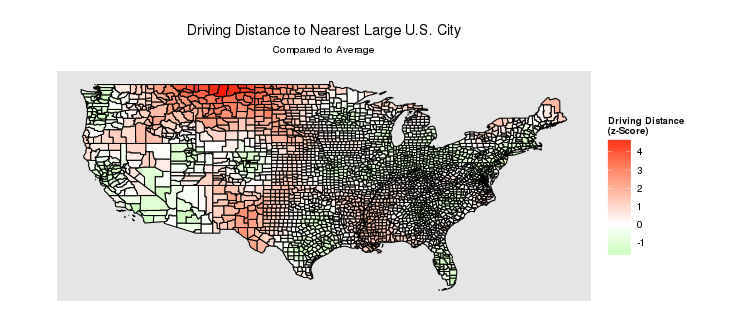
To help visualize this data, here is a map of the z-score of the shortest driving distance for each county:
For more information on this topic, please see the County Density/Distance/Population Map.