render natural=earth_bank #2288
Comments
|
A cliff does not necessarily have to be solid rock. There are many cases of soft sediment erosion along coasts, with pretty giant and high "cliffs" being formed that would definitely not classify as gully or valley, e.g. along the coast of the UK (see this page of the British Geological Society: http://www.bgs.ac.uk/landslides/happisburgh.html - especially note the explicit usage of the word "cliff" on that page). I think the usage you are showing is within the limits of acceptable tagging for this. Alternatively, if the "gully" is actually a man_made=cutting, using the man_made=embankment tag would be an option. |
|
sent from a phone
??? Why the embankment and not the cutting tag if it's a cutting? |
Agree. natural=cliff is about "almost vertical drop" (see wiki). Almost always you get them with solid formations (simply put, "rocks"). But with coastal erosion you can get natural=cliff (a vertical drop) out of everything, yes.
http://taginfo.openstreetmap.org/tags/man_made=cutting has only 60 uses ATM and wasn't described at wiki. I don't see "almost vertical drops" based on Bing/other imagery here: Yes, they are steep, but not "near vertical" (natural=cliff). They are natural (not man_made=embankment) and most likely |
|
Other option is to tag http://www.bgs.ac.uk/landslides/happisburgh.html with natural=earth_bank + earth_bank=сut_bank (a river bank, erosion http://wiki.openstreetmap.org/wiki/File:Earth_bank_cut_bank.jpg) |
Actually, for all natural or man_made "embankments" and "cuttings" there is a kind of grey area for very large and wide ones (yes even man_made ones can be extremely wide and huge): To some extent, these large natural cliffs / gullies represent both: it depends on your current position and perception, whether your would perceive them as an embankment or cutting: if you are "down there", you would probably classify them as an "embankment". If you are "on the top", you might be more persuaded to call it a "cutting"... So to some extent, these terms are interchangeable (and especially for the large and wide ones). Anyway, only man_made=embankment is currently rendered by Carto AFAIK...
Yes, you are right, I referred to a marginal undocumented tag... Probably a bad choice.
I have no idea how natural=valley plays a role here: valleys should not be rendered with a "cliff" like symbol. Imagine all valleys in the Alps bordered with such a "cliff" symbol... Gully would be more of an option for a cliff like rendering: it is much closer to the kind of geological structure you seem to refer too, and generally much smaller. |
This comment has been minimized.
This comment has been minimized.
This comment has been minimized.
This comment has been minimized.
This comment has been minimized.
This comment has been minimized.
This comment has been minimized.
This comment has been minimized.
This comment has been minimized.
This comment has been minimized.
|
I feel this is getting too much into a discussion on how to tag rather than a discussion on OpenStreetMap Carto. For the former, please use the tagging@ list or another suitable forum. |
|
@pnorman, well rendering was proposed at wiki:
We are talking about another synonym to natural=cliff/embankment, right? |

|
sent from a phone
thank you for this interesting example. Btw, I wouldn't call these "cuttings" but maybe open pit mining, or excavation, this is not a "cut" anymore if it is on huge areas like here. I think the word that people are looking for here is "slope",i.e. somehow similar to a cliff, but less steep. I would not use the same signature for cliffs and slopes. |
Completely agree ;-), calling these features "cuttings" was a stretch... only for the sake of the argument and to illustrate the story behind it. |
|
For those, who do not live in areas heavily transformed by gullies, photos below might help. This is vast, complicated and old gully, recently mapped (incorrectly) as cliff: Obviously, earth bank is more suitable, but it do not render, giving false impression of regular, flat beech forest, very easy to traverse. In reality you can quiclkly get lost in best, or fell off in worst case. Fresh ,,cuttings'' are nearly vertical (usually after heavy thunderstorm). Old are not vertical, but still very steep.
|


|
Thanks for reminding about it. I guess now it makes sense, since the usage is visible (2275 uses) - would you like to prepare the code? https://taginfo.openstreetmap.org/tags/natural=earth_bank
|

|
Using the same pattern as |
|
I don't know. I guess this is closer to natural=cliff. Maybe some pattern should be different or maybe just less dense for example? It's always better if the mapper sees more precise feedback, but it's not always easy to tell what is the difference between tags. |
|
If this tag is to be rendered, it should be added to the list of linestring exceptions for the key "natural" (which is usually imported as a polygon when mapped on a closed way), similar to natural=cliff and man_made=embankment However, it's not clear to me why this tag is needed. Is it for smaller features than natural=cliff? It would benefit from a RFC and proposal process with the Tagging mailing list. |
|
I think the idea is that natural=cliff is meant for a vertical or near vertical drop which essentially implies a solid material like rock. Therefore some mappers felt it is less appropriate to use the same tag for erosion structures in softer material which are often not that steep. Unfortunately the tag is now used for a relatively wide range of structures, both with active erosion resulting in a sharp edge and stabilized slopes, essentially any type of naturally occurring steep slope in soft ground originally produced by erosion. But there are also >600 uses of earth_bank=* for further differentiation. There is overlap in use of natural=cliff and natural=earth_bank. The latter is in particular popular in Russia where structures like this: https://www.openstreetmap.org/way/120547840 would most likely be tagged this way. |
|
What about rendering in the same style as man_made=embankment as proposed above? |
|
The problem is that lots of mappers use cliff to map gully or mound. You can look at the current map of St.Petersburg, Russia - it's full of cliffs on the map. But it is completely flat. Flat! Yes, it's incorrect mapping and I can change tagging. But it will last for several days, no more. Poor mappers will come and turn everything back just because they do not see them on map. |
|
Are the |
|
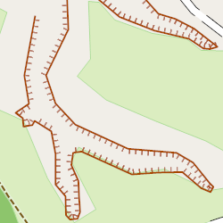
They are exactly like those on photos in #2288 (comment) |
|
How about making |
|
I can confirm that I see natural=cliff everywhere instead of natural=earth_bank This needs to be shown on the map, otherwise people will continue to use natural=cliff incorrectly. |
|
I think that the wiki entry provides an easy and practical distinction between "cliff" and "earth_bank":
So, in other words, a "cliff" is a rocky wall, which could be likely used for rock climbing, while an "earth_bank" is a slope, which may be more or less steep, more ore less rocky. Now, I'm not a geologist, but I would say that the "earth_bank" is carved by streams and rivers, while the "cliff" is the result of the movements of the Earth's crust. In any case, I believe that "earth_bank" should be rendered in a better way than the currently not rendered basic green line. |
|
Did anybody get to a proposed patch here? I'm about to map a few slopes as cliffs for now :) |
|
Looks like something like |
|
That's still slightly incorrect tagging, as it's not man_made in that case. |
|
Yes, it is not man_made, that's the point. You can do auto-convert |
|
A very nice hack, thank you for the clarification :) |
Rendering and details present at wiki: natural=earth_bank
Some rationale "why another alias to cliff?" below
natural=cliff was defined at wiki with close relation to natural rocks, but natural=cliff was heavily tagged for rendering:http://www.openstreetmap.org/way/191570269
http://www.openstreetmap.org/way/191570270
By many users, everywhere. Personally I relate this because of the symbols in "карты генштаба" maps.The text was updated successfully, but these errors were encountered: