Blog post: https://forensenellanebbia.blogspot.com/2015/08/geotag2kml-python-script-to-create-kml.html
The is a cross-platform script that uses ExifTool to find geotagged files and parse their metadata. It then creates two different Google Earth .KML files to display the photos/videos found.
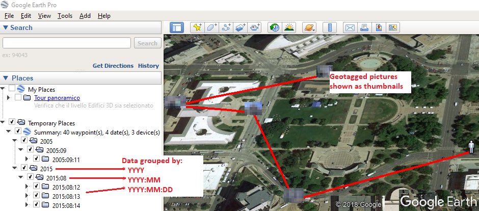
The .KML file will be structured this way:
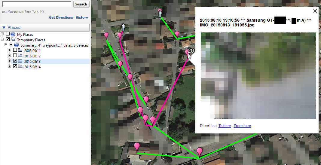
- GPS points are grouped and sorted by YYYY | YYYY:MM | YYYY:MM:DD;
- the first GPS point of each date is indicated with an icon different from the other points of the same date;
- the GPS points occurred on the same date are connected with a colored line;
- placemark names contain: "Timestamp | Make Model | Filename";
- when clicking on a placemark icon, the picture preview appears.
- Python v3.8+
- Exiftool
- ImageMagick (Win/Mac) or libheif (Ubuntu)
#Python3 dependencies
- pip3 install geopy Pillow randomcolor
#Windows 10 x64
- ExifTool: https://exiftool.org/ (rename the executable to exiftool.exe)
- ImageMagick: https://imagemagick.org/script/download.php#windows (Win64 dynamic at 16 bits-per-pixel component)
#Ubuntu (last tested with Ubuntu 22.04.1 LTS)
#ExifTool
sudo apt install libimage-exiftool-perl -y

#libheif
sudo apt-get install libheif-examples

#Google Earth
wget -O ~/google-earth.deb https://dl.google.com/dl/earth/client/current/google-earth-pro-stable_current_amd64.deb && sudo dpkg -i ~/google-earth.deb
#Mac OS (tested with macOS Big Sur 11.0.1)
- If you're having any issue while installing Pillow, try:
/bin/bash -c "$(curl -fsSL https://raw.githubusercontent.com/Homebrew/install/HEAD/install.sh)" && brew install libjpeg && pip3 install Pillow --user- ExifTool: https://exiftool.org/ (MacOS Package)
- ImageMagick
brew install imagemagickRun the script and type the absolute path of the directory to parse. Examples:
- Microsoft Windows: python3 geotag2kml.py C:\MyPhotos
- Ubuntu: python3 geotag2kml.py /home/username/Desktop/Photos
The output files will be saved under the given path.