This repository includes bash scripts that use Generic Mapping Tools (Wessel et al., 2013) to plot National Observatory of Athens NOA earthquake catalogue and historical earthquakes of Papazachos and Papazachou catalogue for the region of Greece. Also you can plot earthquake profiles ...
main scripts
- plot_eq.sh : plot earthquakes
- plot_eq_proj.sh : plot earthquakes and profiles
- plot_hcmt.sh : plot moment tensors from historic earthquakes
helpful files
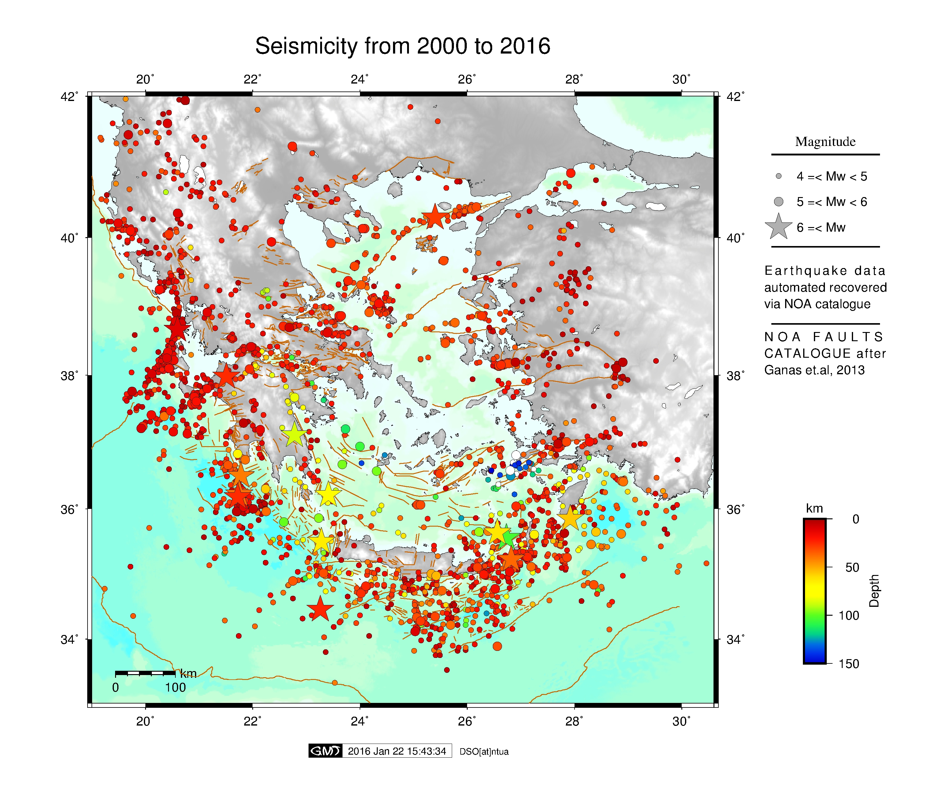
- default-param : default parameters for paths, input files and region configuration
- get_catalogue.sh : this script download earthquake NOA catalogue and fault database (Ganas et al., 2020)
- Be sure that gmt is installed on your computer
- Configure file default-param.
If you'd like to use topography, you can download world DEM from here
# //////////////////
# Set PATHS parameters
pth2dems=${HOME}/Map_project/dems
inputTopoL=${pth2dems}/ETOPO1_Bed_g_gmt4.grd
inputTopoB=${pth2dems}/ETOPO1_Bed_g_gmt4.grd
pth2logos=$HOME/Map_project/logos
pth2faults=$HOME/Map_project/faults/NOAFaults_v5.01.gmt

#///////////////////
# Set default REGION for GREECE
west=19
east=30.6
south=33
north=42
projscale=6000000
frame=2
For main scripts help function run:
  $> ./plot_eq.sh -h
  ## (or)
  $> ./plot_eq_proj.sh -h
plot_eq.sh
MAIN OPTIONS
Usage : plot_eq.sh -r west east south north | -topo | -o [output] | -jpg
- r [:= region] region to plot west east south north (default Greece) use: -r west east south north projscale frame
- mt [:= map title] title map default none use quotes
- updcat [:= update earthquake catalogue]
- topo [:= topography] use DEM topography
- faults [:= faults] plot NOA fault database
- histeq [:= historic eq ] plot historical eq via papazachos catalogue
EARTHQUAKE OPTIONS
- minmw [:= minimum magnitude] bug use only int
- maxmw [:= maximum magnitude] bug use only int
- starty [:= start year]
- stopy [:= stop year]
OTHER OPRTIONS
- o [:= output] name of output files
- l [:=labels] plot labels
- leg [:=legend] insert legends
- logo [:=logo] plot logo
- jpg : convert eps file to jpg
- h [:= help] help menu
Exit Status: 1 -> help message or error
Exit Status: >= 0 -> sucesseful exit
$ ./plot_eq.sh -topo -faults -jpg -leg
plot_eq_proj.sh In these script added an optio to plot rofile of earthquakes
-eqproj [:=projection] plot projectio along profile
use -eqproj lon lat Az Lmin Lmax Wmin Wmax depth
lon: start longitude of profile
lat: start latitude of profile
Az: Azimuth of profile
Lmin, Lmax: Profile Length start-stop
Wmin, Wmax: Profile width on the two sides of profile depth: depth of profile
- 21-1-2015: online version is available
- 03-8-2023: update to GMT v6.3.0, bug fixed
Athanassios Ganas. (2023). NOAFAULTS KMZ layer Version 5.0 (V5.0) [Data set]. Zenodo. https://doi.org/10.5281/zenodo.8075517
Ganas Athanassios, Oikonomou Athanassia I., and Tsimi Christina, 2013. NOAFAULTS: a digital database for active faults in Greece. Bulletin of the Geological Society of Greece, vol. XLVII and Proceedings of the 13th International Congress, Chania, Sept. 2013.
Wessel, P., Luis, J. F., Uieda, L., Scharroo, R., Wobbe, F., Smith, W. H. F., & Tian, D. (2019). The Generic Mapping Tools version 6. Geochemistry, Geophysics, Geosystems, 20, 5556–5564. https://doi.org/10.1029/2019GC008515
Dimitris Anastasiou, danastasiou@mail.ntua.gr
Xanthos Papanikolaou, xanthos@mail.ntua.gr