This repository includes bash scripts that use Generic Mapping Tools (Wessel et al., 2013) to plot all continuous and campaign GNSS networks processed at DSO automated platform and campaign networks. Also a new script added to plot metadata from a MySQL, processed and unprocessed stations from a network, rms and baselined formed for the data processing.
#configuration files
- dbparameters copy dbparameters.default file to dbparameters and edit the variables to connect your database
#!bin/bash
#configure this file for the main database parameters
dbhost="database_hostname"
dbuser="username"
dbpasswd="password"
dbase="database_name"
db_table="database table"
db_code="column name with stations codes"
db_lat="column name include latitude"
db_lon="column name include longitude"
- gmtparam : config all gmt parameters, input and output file, paths, styles etc
- regparam : NOT USED
If you don't use database you must set input files as bellow (only for scripts cGNSSnets.sh campaign_nets.sh)
name:network.sites
CODE longitute latitude
plot all available continuous GNSS stations in Greece
use -h (help) to see all available switces
/******************************************************************************/
	Program Name : cGNSSnets.sh
	Version : v-1.0
	Purpose : Plot cGNSS network stations
	Usage   : cGNSSnets.sh -r region |  | -o [output] | -jpg
Switches:
	-r [:= region] region to plot [saegean, sant, extsant]
		default : greece region
		sant : santorini
		extsant : extented santorini
		saegean : South aegean region
		grCyprus: greece + cyprus
		corinth: corinth rift
	-mt [:= map title] title map default none use quotes
	-fgnss : use file for gps inform (*network*.sites)
	-dbgnss: use database for gps information

/*** NETWORKS  PLOTS **********************************************************/
	-ggr [:= gps greece] Plot GPS Stations
	-ggrcom [:= gps COMET] Plot GPS Stations
	-ggrnoa [:= gps NOANET] Plot GPS Stations
	-ggrcrl [:= gps CRL] Plot GPS Stations
	-ggreth [:=jHellas -ethz]

	-gsa [:= gps santorini]
	-gur [:= gps uranus]
	-gme [:= gps mterica]
	-ghp [:= gps hepos]

/*** OTHER OPRTIONS ************************************************************/
	-topo [:=topography] use dem for background
	-o [:= output] name of output files
	-l [:=labels] plot labels
	-leg [:=legend] insert legends
	-jpg : convert eps file to jpg
	-h [:= help] help menu

	Exit Status:    1 -> help message or error
	Exit Status:    0 -> sucesseful exit

	run:
/******************************************************************************/
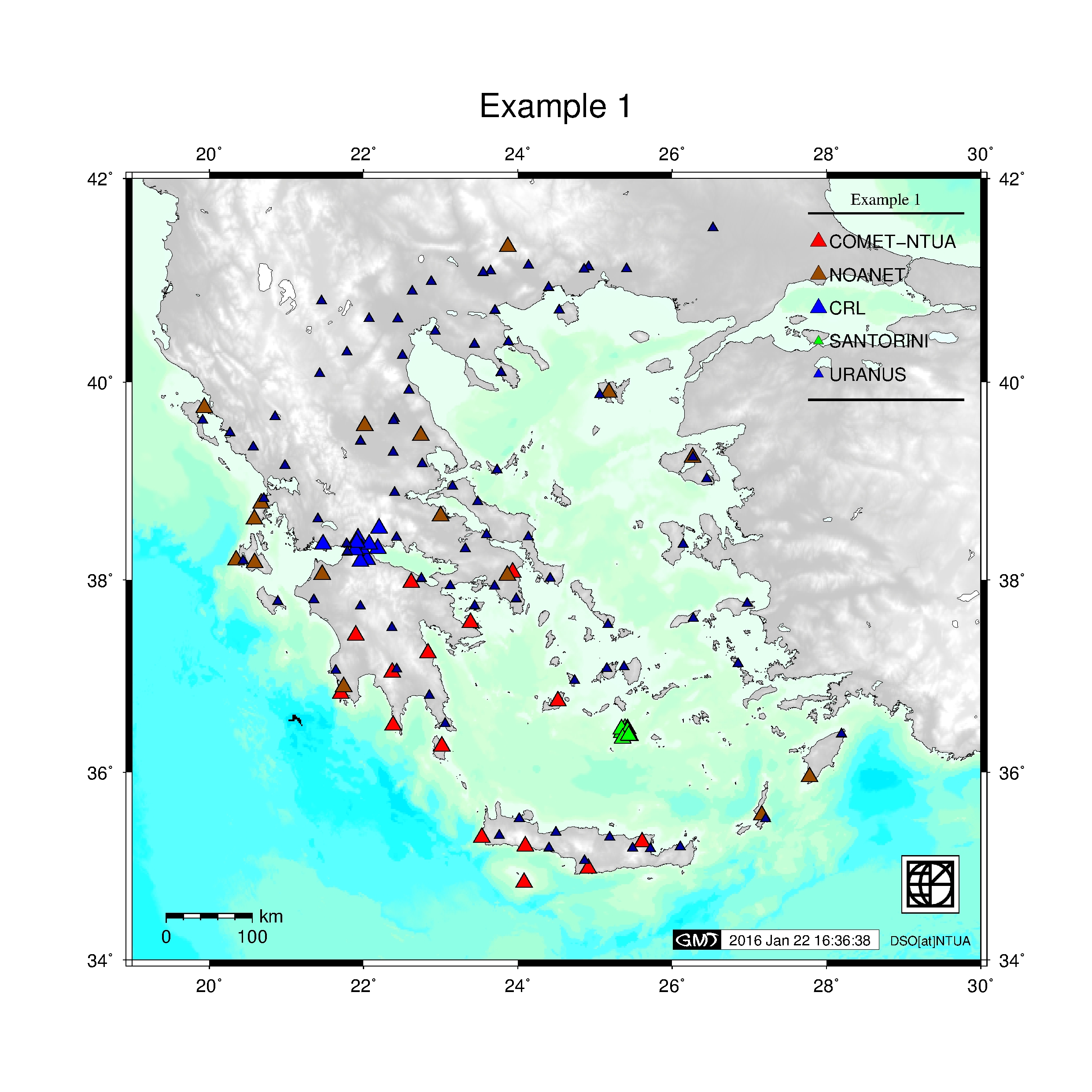
$ ./cGNSSnets.sh -fgnss -jpg -topo -leg -logo -o test -ggrcom -ggrnoa -ggrcrl -gsa -gur -mt "Example 1"
plot all available campaign GPS stations in Greece
use -h (help) to see all available switces
/******************************************************************************/
	Program Name : campaign_nets.sh
	Version : v-0.1
	Purpose : Plot cGNSS network stations
	Usage   :campaign_nets.sh -r region |  | -o [output] | -jpg
Switches:
	-r [:= region] region to plot [saegean, sant, extsant]
		default : greece region
		sant : santorini
		extsant : extented santorini
		saegean : South aegean region
		grCyprus: greece + cyprus
		corinth: corinth rift
	-mt [:= map title] title map default none use quotes
	-fgnss : use file for gps inform (*network*.sites)
	-dbgnss: use database for gps information

/*** CAMPAIGN NETWORKS  PLOTS **********************************************************/
	-cAegean [:= campaign Aegean]
	-cCentrGR [:= campaign central greece]
	-cCorinth [:= campaign corinth]
	-cEvia [:= campaign Evia]
	-cGrevena [:= campaign Grevena]
	-cHELLNET [:= campaign HEELNET]
	-cIonian [:= campaign Ionian]
	-cRoads [:= campaign Roads]
	-cSING [:= campaign SING] Plot GPS Stations

/*** OTHER OPRTIONS ************************************************************/
	-topo [:=topography] use dem for background
	-o [:= output] name of output files
	-l [:=labels] plot labels
	-leg [:=legend] insert legends
	-jpg : convert eps file to jpg
	-h [:= help] help menu

	Exit Status:    1 -> help message or error
	Exit Status:    0 -> sucesseful exit

	run:
/******************************************************************************/
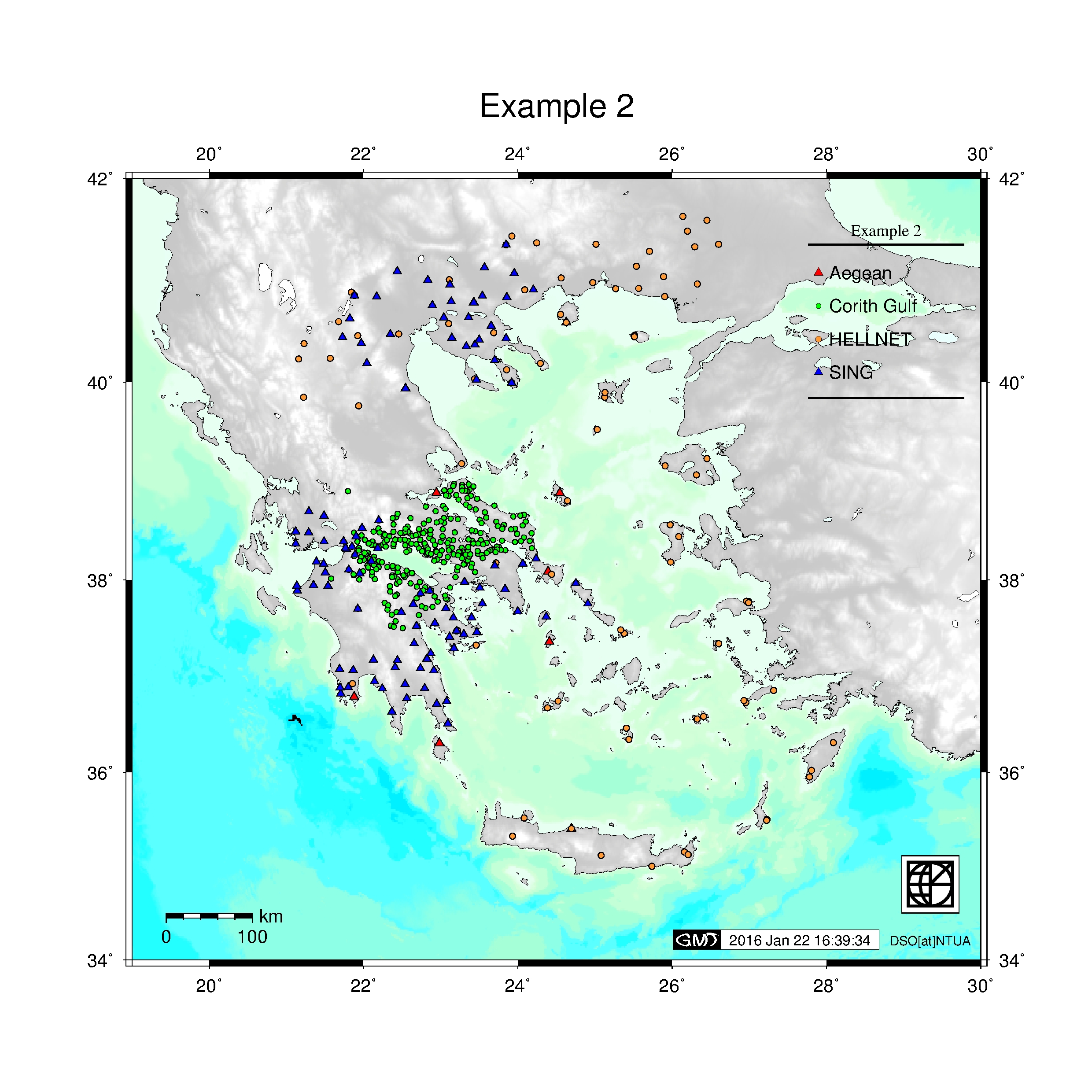
$ ./campaign_nets.sh -topo -jpg -leg -logo -fgnss -cAegean -cCorinth -cHELLNET -cSING -mt "Example 2"
/******************************************************************************/
	Program Name : cGNSSproc.sh
	Version : v-1.0
	Purpose : Plot cGNSS network stations from procsta database
	Usage   : cGNSSnets.sh -r region |  | -o [output] | -jpg
Switches:
	-r [:= region] region to plot [saegean, sant, extsant]
		default : greece region
		sant : santorini
		extsant : extented santorini
		saegean : South aegean region
		grCyprus: greece + cyprus
		corinth: corinth rift
		europe: europe region
	-mt [:= map title] title map default none use quotes

/*** NETWORKS  PLOTS **********************************************************/
	-n (network) %select processed network from bellow
	   greece
	   uranus
	   santorini
	   ....etc

/*** SOLUTION PLOTS **********************************************************/
	-s (sol file)
	   -pall : plot all station network
	   -ppro : plot processing stations
	   -pell : plot ellipsis
	   -pbl  : plot baselines

/*** OTHER OPRTIONS ************************************************************/
	-topo [:=topography] use dem for background
	-o [:= output] name of output files
	-l [:=labels] plot labels
	-leg [:=legend] insert legends
	-logo [:=logo] plot logo
	-jpg : convert eps file to jpg
	-h [:= help] help menu

	Exit Status:    1 -> help message or error
	Exit Status:    0 -> sucesseful exit

	run:
/******************************************************************************/
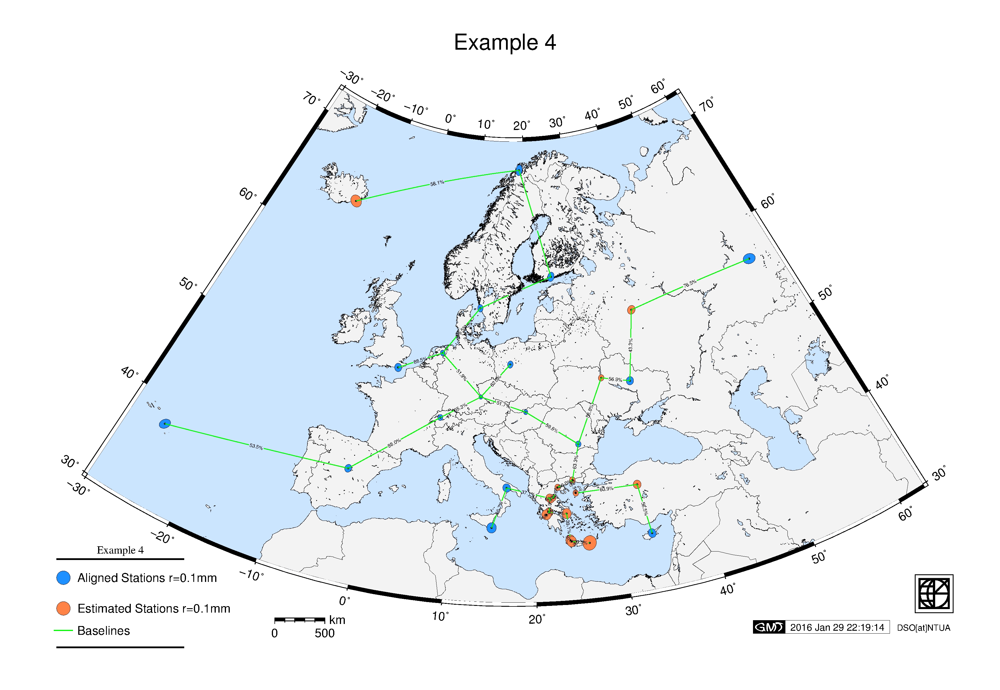
For plotting solution metadata should be created a solution file following the structure bellow:
# this is comments!
# FOR PROCESSED STATIONS:
##  CODE dx       dy      dz       rms_x  rms_y   rms_z    ell_a    ell_b     Az   typ  Longtitude Latitude   Height
##* **** ******* ******* ********  ****** ******* ******* ******** ******** ****** *** ********** ********** ******
01 ANKR  0.0148  0.00523 -0.00036 -0.0101 -0.0034 0.01154 0.000570 0.000620 085.80 EST 39.8873712 32.7584698 976.02
# FOR BASELINES (use BL for fisst 2 chars)
##  lat 1         lon 1         lat2         lon2     amb  typ
## *********** ************ ************ ************ **** ***
BL 40.56681913 23.003721009 41.140212284 24.916801994 66.0 W/N
take a look also at example file greece-15002-fin.proc
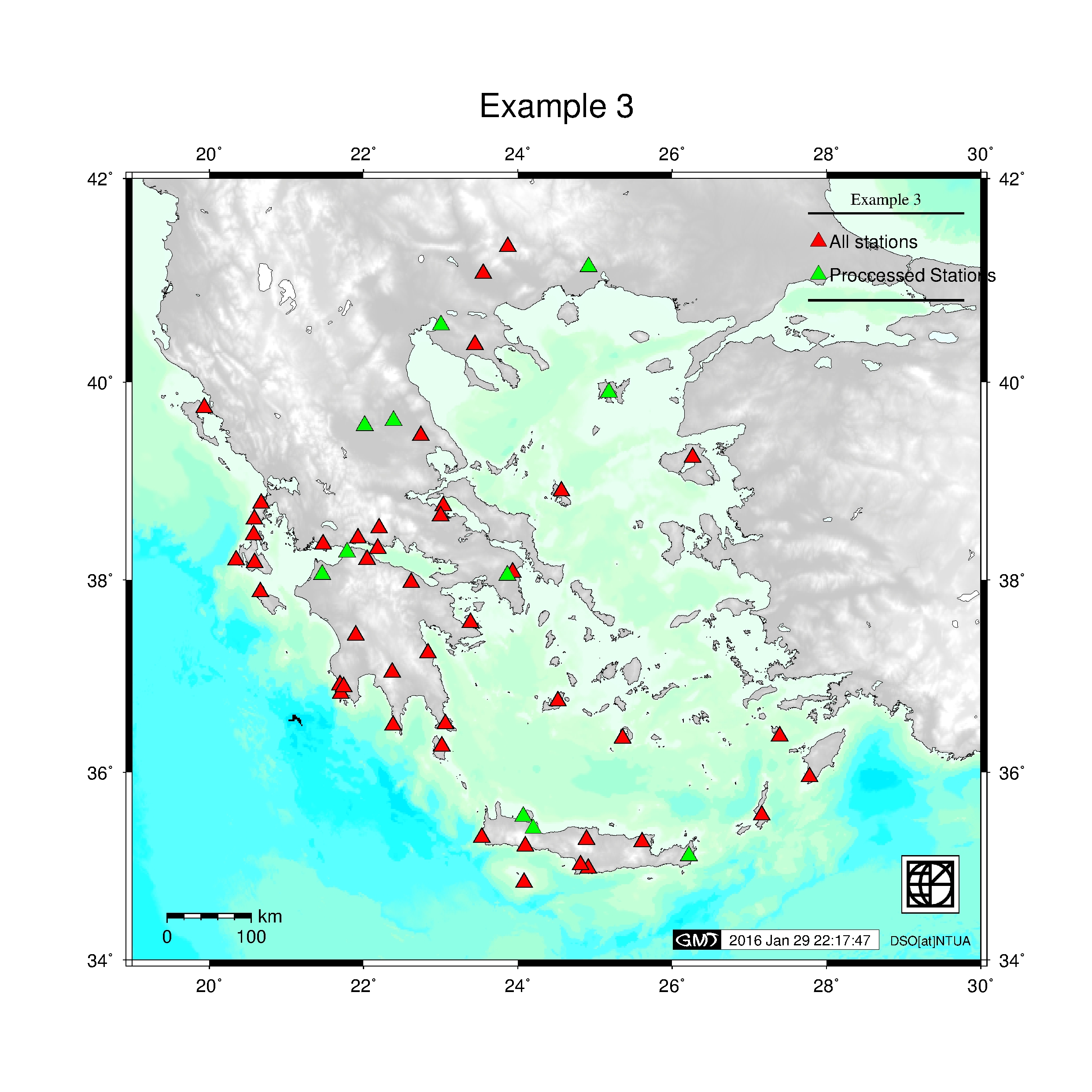
Plot processed and unrocessed stations for network greece.
$ ./cGNSSproc.sh -n greece -jpg -s greece-15002-fin.proc -pall -ppro -leg -topo -mt "Example 3" -logo -o Example3
Plot Helmert rms and baselines for network greece
./cGNSSproc.sh -r europe -n greece -jpg -s greece-15002-fin.proc -pell -pbl -mt "Example 4" -leg -logo -o Example4
- 29-1-2015: added cGNSSpros.sh script
- 21-1-2015: online version is available
Wessel, P., W. H. F. Smith, R. Scharroo, J. F. Luis, and F. Wobbe, Generic Mapping Tools: Improved version released, EOS Trans. AGU, 94, 409-410, 2013.
Demitris Anastasiou, danast@mail.ntua.gr
Xanthos Papanikolaou, xanthos@mail.ntua.gr