Wayfinding indoors still has not been studied to the same extent as wayfind-ing outdoors. Though some approaches have been explored in recent studies forindoor navigation, no standard methods exist. Motivated recently-emersed Augmented Reality and Mixed Reality technologies, this research demonstrates a feasible workflow of developing a Mixed Reality indoor navigation system, HoloNav,on Microsoft HoloLens 2. The system utilized Azure Spatial Anchors as virtualmarkers for labeling landmarks. A user study was conducted on the two variantsof HoloNav designed with two different navigation visualizations to help gaininformation about the kind of visualizations preferred in a Mixed Reality navigation system. Furthermore, the benefits of Mixed Reality navigation systemscompared to traditional systems are also highlighted and discussed via a user study with more than twenty users.
For more details about the project, checkout our report
- Mapping
- Create new anchors of interest in the environment
- Populate auxillary information
- Navigation
- Choose from the created anchors an origin and a destination.
- Generate the shortest path between these two anchors using Dijkstra’s algorithm
- Render the navigation visualizations indicating the route
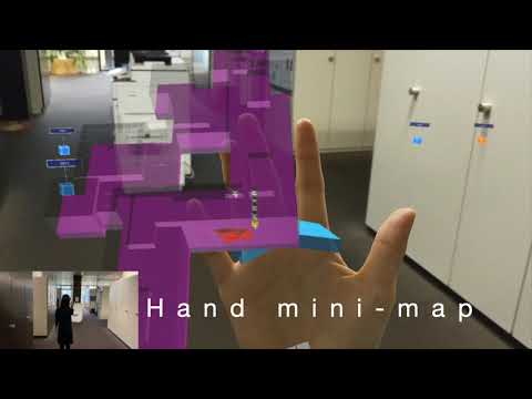
- Two navigation visualizations supported
- Hand-invoked minimap + arrows as navigation visualization
- Static minimap + transition lines as navigation visualization
HoloNav leverages ESRI CityEngine and Azure Spatial Anchor to provide future solution for indoor navigation. Powered by Microsoft HoloLens 2 and its advanced Mixed Reality (MR) features, HoloNav enables efficient and effective indoor localization and navigation as well as direct manipulation with the hand-invoked mini-map, contributing to interactive and immersive user experiences. The application explores possible interaction concepts and visualizations of MR-based indoor navigation systems on mobile devices and demonstrates a working prototypes that can be extended to further applications.
- Microsoft HoloLens 2
- MRTK v2.5.1
- Azure Spatial Anchor SDK version 2.7.0
- Unity 2019.4.12f1
- Visual Studio 2019 Version 16.5.0
There is a known issue with the FollowMe/Solver Handler function of MRTK on HoloLens 2 with Visual Studio 2019 of version 16.5.0. This issue is claimed to be fixed with the next Visual Studio release, while prior this release, a walkaround would be using MRTK v2.5.0/v2.5.1 (or higher) Foundation together with Tools packages. For previous version of Azure Spatial Anchor SDK, where the account domain is not required, there might be problems. Please use the latest version of SDK for better consistency.
- To access Azure Spatial Anchor, API keys are required, which can be acquired following the tutorial Create Azure Spatial Anchor.
- After the access to Azure Spatial Anchor is settled, corresponding information needs to be added to the project in Unity.
- select "Anchor Manager" from the hierarchy, populate the information in the "Spatial Anchor Manager" in the inspector
- set the "Spatial Anchors Account Id"
- set the "Spatial Anchors Account Key"
- set the "Spatial Anchors Account Domain"
- Our app uses Azure Table Storage as the backend to store information about the anchors. To enable the access, follow the official tutorial Create Azure Table Account.
- After setting up your Azure Table Storage, the following information is needed.
- Open the project with unity, from the hierarchy, select "Data Manager" then input the "Connection String"
- Specify the "Spatial Anchor Table Name", which will store all the auxillary information about the anchors to be created
- Specify the "Adjacent List Table Name", which will store the spatial relationship between the two connected anchors
Note: Azure Table Storage is a free service offer by Azure, which is sufficient for this project, yet Azure does also offer more advanced storage service Azure Cosmos DB. In addition, according to the official documentation, the Table API is integrated to Cosmos DB SDK in the newer version.
Our application is partially adapted based on the following official tutorials.
- To get around with Azure Spatial Anchor, we suggest checking out the HoloLens's official tutorials on Azure Spatial Anchors.
- For integrating Azure Cloud Services into the app, we found the tutorials on Azure Cloud Services for HoloLens 2 very useful.
Tianyu Wu, Laura Schalbette, and Xavier Brunnner
In completion of Interdisciplinary Project Thesis 2019, ETH Zurich