(Developer: Deirdre McCarthy)
- About
- Project Goals:
- UX Design - Scope
- User goals/ user stories:
- Further UX Design:
- Features
- Technology
- Validation
- HTML Validation
- CSS Validation
- Accessibility
- Performance
- Multi-device Testing
- Multi-browser Testing
- Testing user stories
- [Feature testing(#rtm-proof)]
- Unfixed Bugs
- Accessibility
- Performance
- Deployment
- Credits
This website highlights jogging, hiking and walking trails available in the Arklow, Co. Wicklow area of Ireland. It is designed for recreational runners and walkers, which may include tourists (First-time and Returning site visitors), and local people (typically Returning site visitors).
The site is intended to raise awareness of Arklow's community walking routes, to highlight the natural and urban landscape of Arklow, and, as a tourism aid, to showcase some of the pleasant and interesting features within Arklow Town. Site visitors are invited to participate in developing the site by contributing their own feedback and photos.
The site exists primarily to showcase available walking/jogging trails, to make people aware of the facilities available on each trail, and to assist them in navigating independently to a starting point.
Notice that the images on this website show trails, landscapes, animals and objects rather than people. The intention is to focus largely on the trails, thus encouraging independent access to the routes. Visitors are made aware of, and invited to participate in, the informal Trail Trotter runs/ walks (facebook link in footer).
https://ui.dev/amiresponsive?url=https://deemccart.github.io/CI_PP1_ArklowTrails/
https://deemccart.github.io/CI_PP1_ArklowTrails
To produce a user-friendly, informative website of walks and trails in the Arklow geographical area.
The aim of this specific website is to increase the 'brand awareness' of Arklow as an active tourism destination.
This website also acts as a 'proof of concept' for a re-usable location-focussed walks site which can be re-configured for individual localities and paired with Google maps data for walks in those localities.
While the site as implemented stands indepdendently, potentially this is an offshoot of the Wicklow Tourism, Failte ireland or other partner website.
The audience is:
a. Tourists visiting the locality, who wish to explore the area on foot
b. Local residents who wish to explore the area
Note that both these groups may have varying mobility capabilities, and therefore it is important to flag if certain routes are wheelchair/ pushchair friendly.
c. Groups on school tours or day outings who are seeking (possibly guided) walks
Existing walking guide sites covering this locality include:
https://www.alltrails.com/ireland/county-wicklow/arklow
https://www.visitarklow.ie/nature-outdoors/walks
https://www.visitarklow.ie/post/4-family-friendly-trails-in-arklow-town-great-for-a-walk-cycle-or-scoot
https://www.visitarklow.ie/post/arklow-town-heritage-walks
https://www.coillte.ie/site/glenart-wood/
https://www.sportireland.ie/outdoors/walking/trails/
A competitive analysis of these offerings can be seen here https://deemccart.github.io/CI_PP1_ArklowTrails/assets/readme_images/Strategy-competitive-analysis.pdf
From this analysis, a set of possible requirements was identified for a new portal.
In summary, while each of these portals reviewed promotes one or more walks, the data is scattered and inconsistent. Maps are formatted differently on each site (or, worse still, only available behind a paywall). It can be very difficult for a non-local user to interpret or relate to the maps given, as they are topographical rather than street-feature based. In some cases, routes are advertised as being within the town, which in fact are some distance away. It is difficult, without local knowledge, to evaluate whether a walk is accessible and available to particular groups of users.
Few of the available websites facilitate independent navigation to the walk routes. None of the existing sites includes the full range of available trails, and portals don't consistently include actual route maps and parking information.
While the competitor research was done by targeting a particular geographic location - Arklow - the problem of difficult-to-find or inaccessible walks data exists throughout Ireland. Multiple providers are offering parts of a solution, and each has their own approach to mapping with varying degrees of usability. For a user to find the available walks in a particular area, they would need to first be aware of organisations that might have an offering (Coillte, Sport Ireland, Wicklow Tourism etc). This in itself requires a certain familiarity with Irish public bodies. The user must then navigate the quirks of individual portals to arrive at a mapped offering which might not need their needs (e.g. sophisticated hiking map offered to recreational walker ).
The Arklow Trails website therefore proposes to provide a portal whereby standard Google Maps functionality (including navigation) is made available to the end user, and the Google Map acts as an entry point to a database of walks presented on this website. This solution is intended to be scaleable and could be adopted as a standardised portal which can be linked to by multiple partner organisations (Wicklow County Development, Wicklow Local Authorities, Historical Societies, and so on). It is intended that users can navigate the site access information easily, without incurring stress or frustration.
- The target audience includes visitors to, and residents of, Arklow who seek running/walking route information
- The target audience includes recreational walkers, joggers and hikers, alone or in groups.
- Joggers/runners are a particular target audience, and would like to know route difficulty level
- Family groups are a particular target audience, perhaps including mobility challenges - suitability for pushchairs/wheelchairs
- Dog walkers?
The basic requirement for users is to access a usable website that provides information and mapping for a range of trails.
- The target audience seeks assistance to choose an appropriate walk (terrain, distance, safety, accessibility) for their needs
- The target audience may have an interest in local history and wish to learn more via website links (possibly a future enhancement)
- The target audience wishes to know about teashops/ bathrooms en route
The Arklow Trails website, as implemented, features 6 walking trails within a certain geographical locality (Arklow town). Mapped Trail start points (Google maps points-of-interest) and routes (Google maps polylines) are provided. Standardised categories (distance, features, terrain) are applied to each walk, and a narrative description is held for each. A range of associated photos per walk is to be provided.
- NB The target audience are likely to commence using the site on desktop, and then to progress to small-screen use.
They will use this site when they are 'out and about' to: * locate the start of the walk relative to their current location, * (possibly) cross-reference site photos against what their obervations when walking one of the routes * add new photos and reviews, which increase the bank of knowledge about this walk. Therefore the primary site usage is expected to be via mobile devices. Support for a range of device types, and responsiveness to the size of the user's screen are highly important for the successful implementation of this website
- SO_01 As site owner I want to list five (or more) key walks in the Arklow area
- SO_02 As site owner I want to categorize walks to allow users to choose the most appropriate for their needs
- SO_03 As site owner I want to provide a google maps link to the location of each of the walks
- SO_04 As site owner I want to provide an attractive gallery of images which encourage outdoor pursuits in this locality
- SO_05 As site owner I want to raise awareness of local sightseeing items
- SO_06 As site owner I wish to promote responsible dog walking (doggie poop bins)
- SO_07 As site owner I wish to showcase local hospitality business - cafes and tea shops en route
- SO_08 As site owner I wish to promote community engagement by encouraging users to leave reviews and photos of their walk own experience
- SO_09 As site owner I want to encourage awareness of community sponsors including: Arklow Tidy Towns, Arklow Municipal District, Wicklow Sports Partnership, Arklow Maritime Musemu, Arklow Historical Society
- FTU_01 As a first-time user I want to see what trails are available within a geographic area
- FTU_02 As a first-time user I want to see how long a trail is, and how difficult (gradient, terrain) it is
- FTU_03 As a family user I want to know whether it is suitable for pushchairs or young children
- FTU_04 As a first-time user I want to see attractive pictures (to motivate me and others to select a particular trail)
- FTU_05 As a first-time/ family/ recreational user I would like to know what rest/food facilities are available on the route
- FTU_06 As a first-time user I would like to understand how to reach the start point from my current location
- FTU_07 As a first time user I would like to be able to navigate the site and quickly learn its functionality
- RU_01 As a returning user I would like to be able to navigate the site easily and to 'drill into' selected walks
- RU_02 As a returning user I would like to be able to navigate the sites on my mobile device when 'out and about'
- RU_03 As a returning user I would like to be able to view photo gallery for individual walks
- RU_04 As a returning user I would like to locate the start of a walk relative to my own location
- RU_05 As a returning user I would like to have a facility to upload my walk photos and add reviews/comments
- RU_06 As a returning user I would like to be able to suggest other walks of interest and upload information for consideration by the site owners
- OT_01 As a local restaurant/cafe/shop owner, while I don't plan to use the site myself, I would like my business to be promoted as a stop-off
- OT_02 As a local litter warden I would like people to be aware where the doggie poop bins/ bag stores are located
- OT_03 As the local Tidy Towns co-ordinator I would like to promote certain walks where we want to increase foot traffic thereby reducing anti-social activity
- FUT_01 NB In the future, the current site owner role may evolve into two roles - Site Owner and Site Administrator. One or more Site Administrators would take on the roles listed above for specific geographic territories, and a new Site Owner role with overall responsibilities for hosting a bank of trails websites (and possibly for digitising new walks at the site Administrators request)
- FUT_02 In order to process user feedback, a future rule of site moderator (Administrator) will be needed to review and approve submitted reviews and photos, and add them to the trails website databank.
Landing Page
The landing page WF is shown here with 4 sceen resolutions as I found when testing that the Motorola G(7) was truncating to the right hand side for 2-column pictures display, therefore I added an additional responsiveness section to cater for 320-400 pixel screen size. This was really just an issue for the landing page, the remaining screens sized OK for the content.
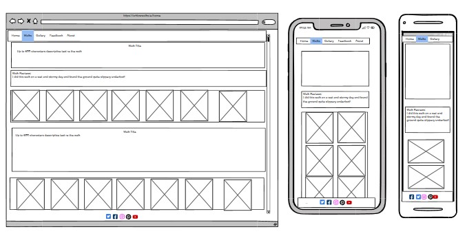
Walk Details
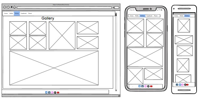
Gallery
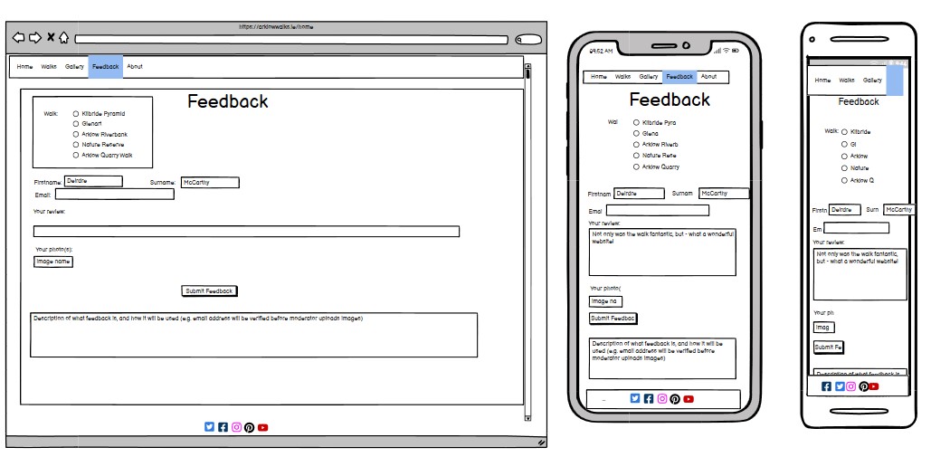
Feedback
 >
>
Libre Franklin and Libre Baskerville are chosen because they are readable on large screens or smaller mobile devices. This font is recommended for sites that may be content-heavy but which are regarded as fun friendly and approachable/inclusive. These are identified by Google as good pairing. Fallback fronts are used in both cases
The colour combinations chosen are blue-green, light-blue, yellow-beige .... somewhat resembling ice cream which is a visual trigger for Arklow as a seaside town! These colours also represent (green) forest, (blue-green) water - river and sea, and (beige/yellow) sand - these are typical landscapes covered by the walks shown, as Arklow is a coastal town sited in a river valley and giving access to large stretches of rocky coastline. the background colours are muted and calm. The background colours are muted to allow foreground images and data to stand out. Background colours are chosen to feel non-threatening and friendly, familiar and safe, so encouraging to users who may be socially hesitant, or feel embarassed about their level of fitness, to feel that the Arklow Trails are inclusive, friendly and will welcome them.
For this particular site the foreground images tend to have strong and meaningful colours. For example the central Google map redendering at the initial scale to show the 6 walks, has a lot of strong blue (sea) and strong green (countryside). Wakls are mapped against the Google map background using strong, vibrant colours which stand out against the map background. The same colour coding is used for the border of each walk flipchart to act as a visual reminder to users of the link between the map and the Arklow Trails website itself.
Colours used for flipchart boundaries per walks: blue-border: rgb(2, 136, 209) fuschia-border: rgb(136, 14, 79) orange-border: rgb(230, 81, 0) yellow-border: rgb(255, 234, 0) sludgegreen-border: rgb(129, 119, 23) purple-border: rgb(103, 58, 183);
This corresponds with the colours which are available within Google maps digitising capabilities, so the rbg values of the mapped walk and its flipcard are consistent.
Digitising options in Google Maps
.This site is reasonably image-heavy, a lot of the interest for users is in creating, uploading or browsing the walk images. Because of the nature of the landscape in the location of Arklow (lots of waterbodies - sea, rivers; lots of green - woods), the images are given sufficient size for the user to be able to view and enjoy. (ref user stories SO_04, FTU_04, RU_03, RU_05)
However a very fundamental aspect of this site is the categorisation of walks, it is not something that shouts out from the site, as the walk gallery photos take a lot of user attention, but in fact the cateogorisation is absolutely key to this site meeting its fundamental user requirement.. (ref user stories SO_02, FTU02, FTU_07)
The approach taken is to use standardised categories, with freely downloadable font-awesome icons throughout the site (most particularly on walk summary flipcards, and on the walk details pages). The range of icons available was not 100% correct, however a reaonsable compromise (e.g. using a 'crow' symbol to represent birdwatching) was found in most cases.
![]()
The use of Google Map was a deliberate design decision. Google maps is widely used by people of all demographics, internationally as well as within Ireland, as a navigation tool. Familiarity reduces the overall learning curve for new users of the Arklow Trails website. Digitising tools available within the Google MyMaps interface, while outside the scope of this document, mean that trails data is presented visually in an attractive, comprehensible way which is meaningful to site users (corresponds to user stories SO_01, SO_03, FTU_01, FTU_07, RU_01 )

Six colour-coded mapped trails are shown. The range of colours means they can be clearly distinguished from one another, and the same colour is used in the flipcard boundary.

The main objective of using consistent colour-coding is to make the site learnable, and act as a visual reminder for users when navigating between mapped walks and their corresponding flipcard. This addresses elements of user stories FTU_01, FTU_07, RU_01

The landing page map is surrounded by colour-edged flipcards, one per walks. The border colour of each flipcard corresponds to the #rgb colour of its associated trail. Each flipcard shows an attractive or intruiging photo, encouraging the user to hover over the image trail information. This cnotributes to user stories SO_04, SO_05, FTU_04, FYU_07, RU_01
 .
.
On larger screens the flipcards are positioned to the left and the right of the main map. On smaller screens, the main map appears first, with the flipcards appearing in either two, or, at smallest, one column below the map.
Hovering over a walk card 'flips' the display to show a walk name and summary detail.
If the user's mouse moves over (desktop) or clicks (mobile) a colour-edged photo, it performs a pleasing shimmy and reveals summary trail data. The user can then select a 'More details' link to access a point within the detailed 'Walks' page:
-
Each card identifies the walk by name and some key features of each walk.
-
Clicking on a particular card opens a link to the relevant walk detail
-
Icons are used within the category cards to categorise distance, trail type (forest/nature/seaside) etc.....
-
The consistent and repeated use of certain icons aids user learning
-
The use of icons improves readability and navigation, particularly for returning users

Standard symbols are used for walk categorisation e.g. birds, sea, swimming, river, forest:
![]()
Each flipcard has a 'More details...' link to encourage the user to access the walk details page:

The flip-card detail is really a navigational aid, to encourage the user to traverse through images on the site, and progressively reveal details of the walks below. On checking summary information the user might immediately think 'oh that walk is too long/short for me, it's not for me' and can quickly move along to the next image and scan the summary there. So its a very nice feature because the user hasn't actually left the landing page and is just moving their mouse around to quickly investigate. Ref user stories
The user can see more details per trail in one of three ways:
- By clicking on the 'more details' link from a flipcard (link to more details for a specific trail)
- By clicking on the URL linked to each trail in Google Maps (link to more details for a specific trail)
- Using the navbar to go directly to the 'Walks' page and scroll to find a walk of interest
Note that there are hyperlinks within page to position at each walk (walk01, walk02, etc )

As per the walks summary flipcard the same symbols are used to help with learning the website
![]()
- clicking on a walk card brings the user to a separate walk details window which provides more information on each walk.
- an explanation of the icons and categories is given on the 'About' page


Ability to view average ratings on scale 1-5 per walk, where 1 = terrible and 5 = fantastic, represented using star symbols (also echoed in the feedback form where the user can enter their own walk ratings)

Helpful descriptions to describe the walk and help the reader determine if it is suitable or of interest to them. This is in accordance with the 'progressive disclosure' principle whereby the user now has chosen to access full details of the walk.

An animated gallery of images is available per walk.
This is a simple html/css animation using a deck of 4 photos per walk with the viewing window transitioning between them.
(This became more complex to implement when I realised that the animation must be iniated by the user rather than auto-play!!).

The navigation bar appears on all pages, and is attractively laid out. Four links are available - Home - Walks - Gallery - Feedback The navbar is visible at the top of each screen, and is identical in each page/ screen size combination to allow for easy navigation. It is fully responsive so will change positioning at 320, 400, 800 pixel screen widths. This section will allow the user to easily navigate from page to page across all devices without having to revert back to the previous page via the ‘back’ button.

As this website is structured to operate more like to a peer-to-peer than a hierarchical structre, the footer bar is not currently used for broadcasting from a single site owner's social links, instead it is a set of 'partner' links to groups or websites which are relevant.
The links will open to a new tab to allow easy navigation for the user. The footer is valuable to the user as it encourages them to keep connected via social media and to engage in a deeper way with the community sponsors of this project
Currently configured to point to:
- Social media/fabebook - Arklow Trail Trotters walking group, with details of their meeting times.
- Visit Wicklow website
- generic youtube
- generic instagram


Although this is fundamental to the successful operation of the site, it is not software that was developed within the Arklow Trails site, and has therefore been left towards the end of the list of 'Arklow Trails' features. Arklow Trails has been designed and implemented so that standard Google maps features (navigation, pan, zoom, choice of mapping background, local points of interest) are still available to the user.
(This presented an implementation challenge as ideally the flipcards would have slightly overlapped the Google Maps screen, and it was intended to implement using z-positioning to overlay.... however when testing it was found that the Google Maps functionality was disabled as the focus was on the flipcards to the forefront... therefore an implementation decision to separate map and flipcards into different screen areas was taken)

As many potential site users are already familiar with Google map usages, the data created for the Arklow Trails website allows users to utilise it compatibly in the Google Maps interface. clicking on either a route or its associated start-point (generally indicated by a colour-coded P on the map) triggers two actions:


Data created for the Arklow Trails website with Google MyMaps included:
- colour-coded walk polylines
- colour-coded startpoints, indicated by a P on the map which are a navigable element within Google
- hyperlinks to walk details within Arklow Trails website, this opens the 'walks detail' page at the relevant section in a new window. (Note that, in implementing, I had intended to use a 3rd party URL shortener however I found that the shortened URL was intermittently disabled/blocked for my test users, so reinstated the longer URL.)
Features in Scope - refer to excel sheet for details of user stories (requirements) features and RTM.
This website includes 5 pages and 13 features Features are as listed in previous section. The pages - which effectively bring these features together - are:
- Landing Page (image link)
- Walks detail page (image link)
- Gallery page (image link)
- Feedback page (image link)
- About page (image link)
- Landing Page The initial website page shows a responsive google map at centre, surrounded by category cards for each of the walks. This section introduces the user to the geographic territory of arklow and the map is useful to give an overview of the walk locations e.g. seaside vs inland. There is very little text (header bar) displayed initially which means that language barriers are reduced and the site becomes very accessible to visually confident users. This page has been designed to be responsive and to display correctly on different screen sizes.

- Walks Page This page shows details of each walk, and is structured with hyperlinks so that focus can be moved directly to a walk of interest (for example when taking 'more details' from a flipcard, or from a google map.)
- Each walk shows a legend with consistent cateogries (distance, features, terrain, average review score)
- Each walk contains text-paragraphs description explaining some of the features of the walk, how it feels to walk it, what a person might see when they are following the route, any items of historical interest etc
- A photo carousel is shown per walk, this allows the user to click to start animation display of a number of stored photos.
- 'Latest review' with star rating is shown.

- Gallery Page
- The gallery displays an attractive set of images taken from various walks - these are not matched against a particular walk, so it acts as a general gallery which showcases the entire locality. This is valuable to all user personas.
Note that images shown in the gallery don't include people but instead highlight the landscape and walk features. It is intended that this be adopted as a policy, both to avoid any data protection issues and also to promote the walks themselves, rather than the people partaking in them.

-
Feedback page This page gives a first-time or returning-user the opportunity to contribute to the content of this site. They can do this by uploading images, ratings or comments (or all 3!) for an existing or indeed a proposed new walk.
-
- This page encourages the user to add their own reviews relating to various walks
- and to upload their photos
- and to add a star rating
- the user must provide a username and email address in order to be permitted to upload photos. They must also accept the terms and conditions.

Some of the user stories could be addressed more directly in the future:
- Include suitability of various walks for dogs? - this has not really been expanded in the current setup, other than mentioning dogs on the walks details text.
- Include details to access guided walks and walking/running groups in the area?
- Moderation of user feedback - text and photos; and ability to upload this into the site content
- Scaling of site - this is currently implemented for a particular geogrpahic location, however the design and implementation principles followed mean that it would be possible to re-use much of the code, and, by creating fresh Google MyMaps digitised routes and updated walk details, to re-use this solution for a different territory. This is definitely something i would like to investigate in the near future.
Requirements traceability matrix showing link between user stories and implemented/ future-release features

- HTML
- CSS
- Github
- Git
- Gitpod
- Balsamiq
- Google Fonts
- Font Awesome
- HTML
- No errors returned on the four website html pages when checked in the W3C validator:
- W3C validator - index page
- W3C validator - walks page
- W3C validator - gallery page
- W3C validator - feedback page
- No errors returned when passing through the official (Jigsaw) validator
The site was tested using the WAVE WebAIM accessibility evaluation tool. All pages pass with 0 errors
- Accessability: index page
- Accessibility: walks page
- Accessibility: gallery page
- Accessibility: feedback page
Running the accessibility checks against the index page identified a problem with the flipcards, which showed text and icons in white against a mid-blue background. This was deemed insufficient contrast so was modified to black text against an aqua background (the same rgb as the header and footer). On the feedback page, there were file upload buttons which had no form label (multiple photo update buttons) After making these changes there were no errors.
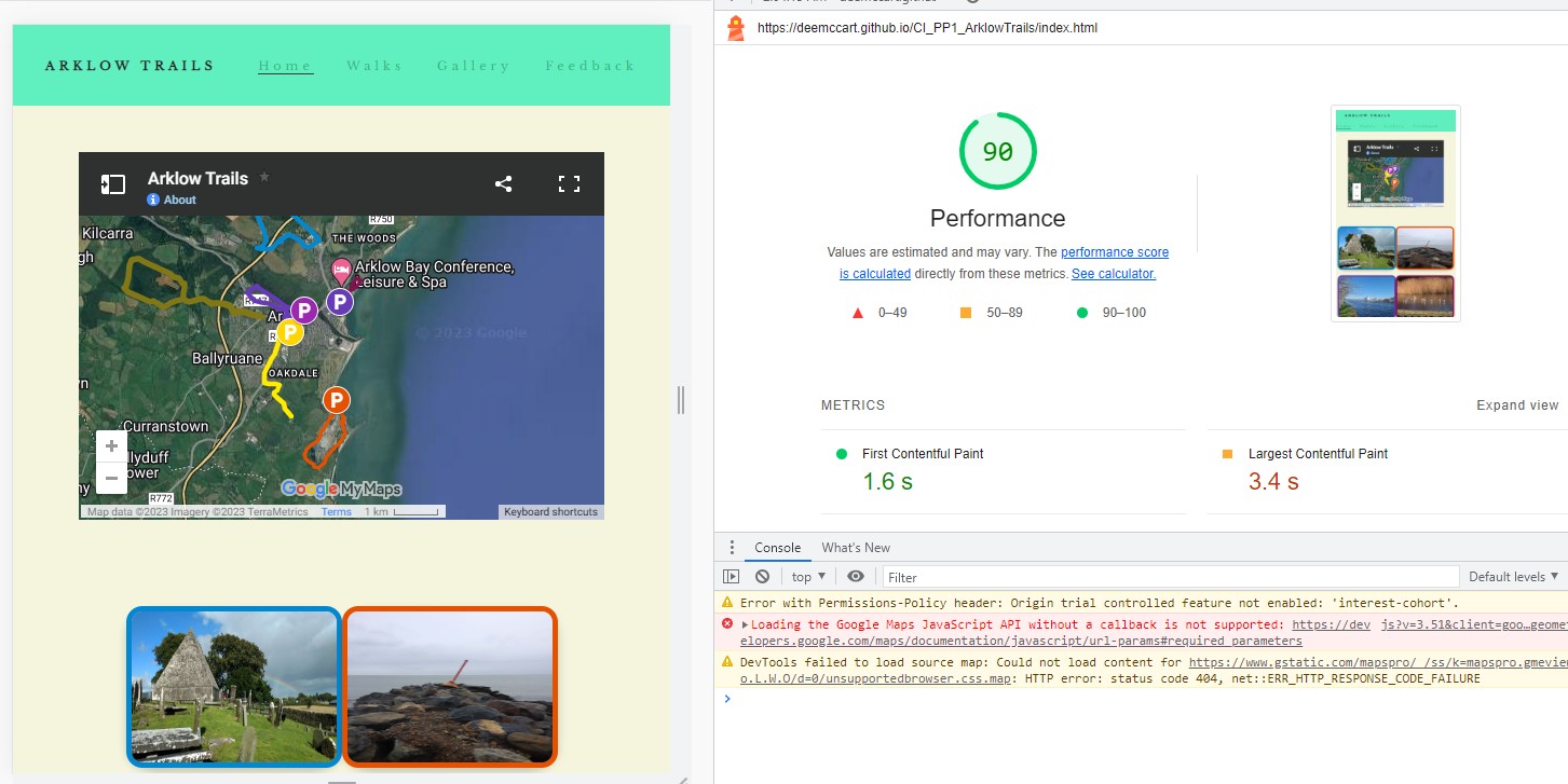
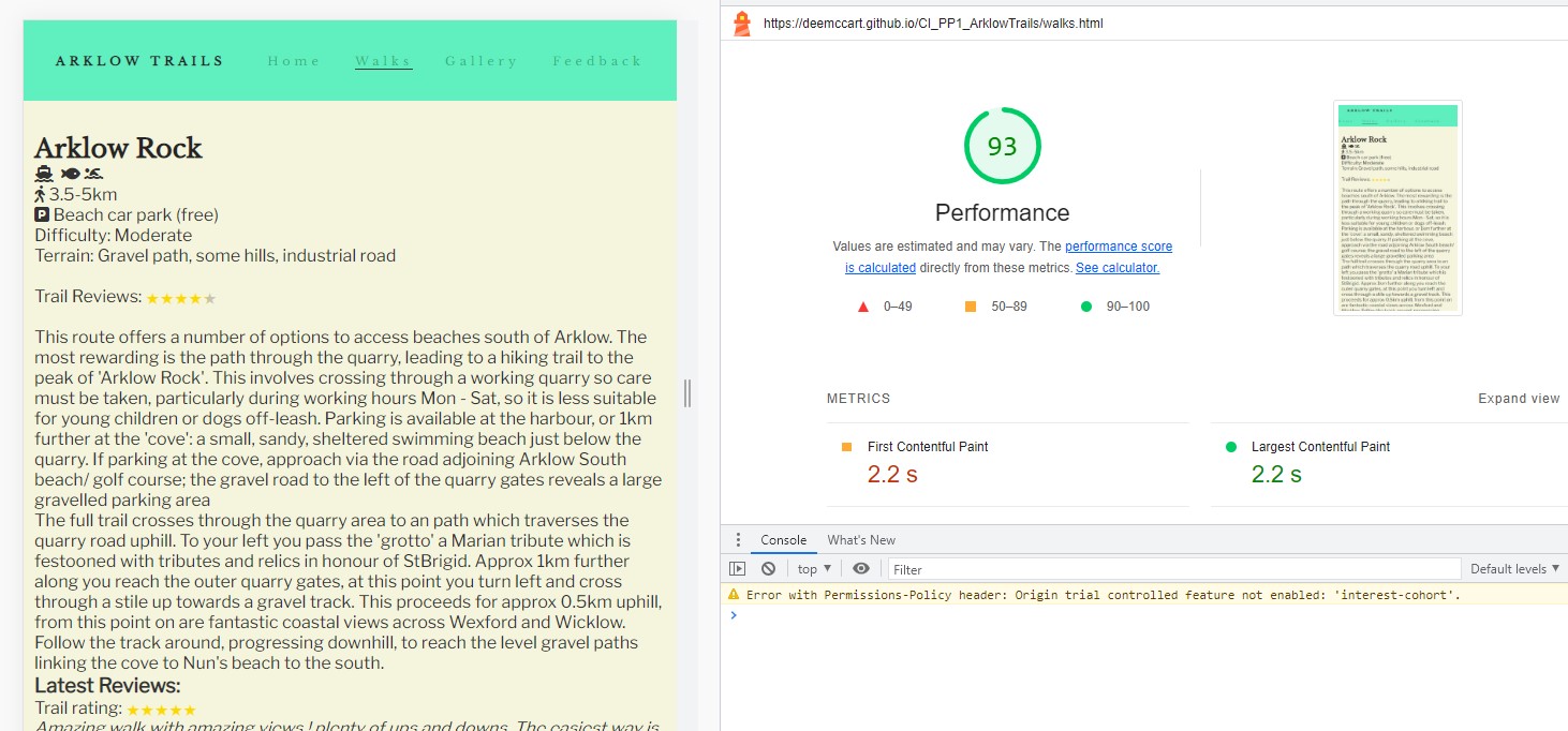
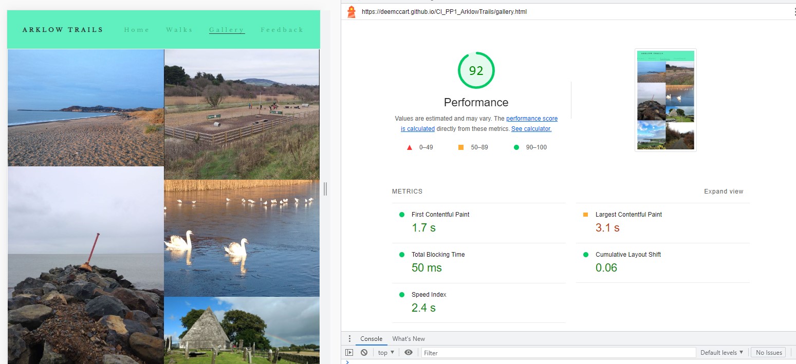
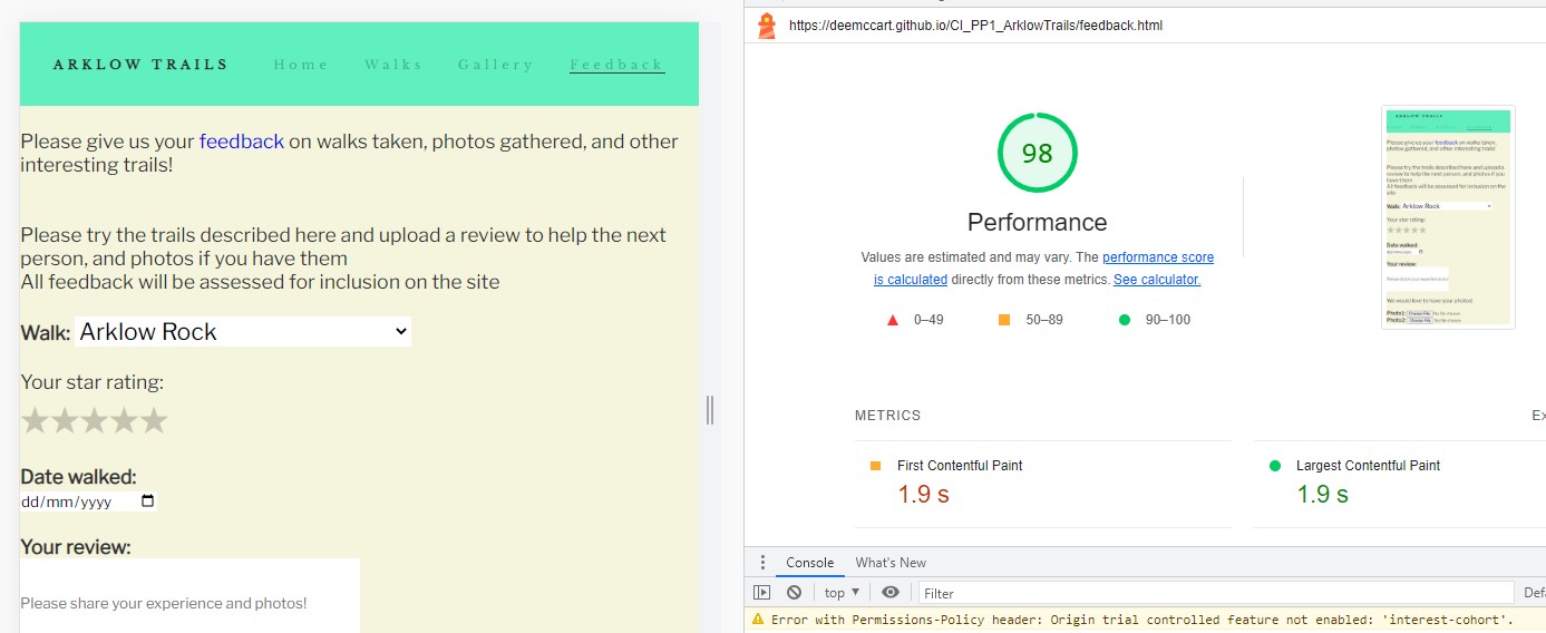
Performance for all pages was tested using the Lighthouse tool within Google Chrome. After adjusting image sizes, performance was at or above 90% for all pages.
Performance: Index page
Performance: Walks page
Performance: Gallery page
Performance: Feedback page
The website was tested on the following devices:
- HP laptop
- Samsung Galaxy S10 tablet
- Motorola G(7) android phone
The website was tested on the following browsers:
- Google Chrome v112.0.5615.138 (HP laptop)
- Google Chrome v112.0.5615.136 (Samsung Galaxy tablet)
- Mozilla Firefox v112.1.0 (Motorola g(7) phone)
User Story Testing The user feature testing is documented in a pdf file: https://deemccart.github.io/CI_PP1_ArklowTrails/assets/readme_images/user-feature-test.pdf
In addition, you should mention in this sectioning how your project looks and works on different browsers and screen sizes.
You should also mention in this section any interesting bugs or problems you discovered during your testing, even if you haven't addressed them yet.
If this section grows too long, you may want to split it off into a separate file and link to it from here.
Requirements traceability matrix showing link between requirements and features Provide proofs of successful testing of each user story### Unfixed Bugs To be completed... mention unfixed bugs and why they were not fixed. This section should include shortcomings of the frameworks or technologies used. Although time can be a big variable to consider, paucity of time and difficulty understanding implementation is not a valid reason to leave bugs unfixed.
This section should describe the process you went through to deploy the project to a hosting platform (e.g. GitHub)
- The site was deployed to GitHub pages. The steps to deploy are as follows:
- In the GitHub repository, navigate to the Settings tab - pages
- From the source section drop-down menu, select the Master Branch
- Once the master branch has been selected, the page will be automatically refreshed with a detailed ribbon display to indicate the successful deployment.
The live link can be found here - https://deemccart.github.io/CI_PP1_ArklowTrails/index.html
Multiple sources were used in assembling this site.
- Text for the Glenart Woods walk was re-used from https://www.coillte.ie/site/glenart-wood/ some text lifted from here also
- Text for Arklow Nature Reserve walk was re-used from https://www.visitarklow.ie/post/4-family-friendly-trails-in-arklow-town-great-for-a-walk-cycle-or-scoot
- Inspiration and content for walks reviews was taken from https://www.alltrails.com/ireland/county-wicklow/arklow
- The icons in the footer were taken from Font Awesome
Images not credited are developer's own.
- Moneylands Farm walk photos came from https://www.moneylandsfarm.com/
- Glenart photos from the following site were re-used https://www.coillte.ie/site/glenart-wood/
- Inspiration for the flipcards came from Elaine B Roche's Thrive project at https://elainebroche-dev.github.io/ms1-thrive/
- How to implement flip card functionality: sourced from W3schools ref https://www.w3schools.com/howto/howto_css_flip_card.asp*/
- For instructions on how to embed a responsive google map into html https://blog.hubspot.com/website/how-to-embed-google-map-in-html
- Google mymaps for specific code to embed in the website
- https://www.w3schools.com/css/css_image_gallery.asp How to create an image gallery
- https://www.w3schools.com/howto/howto_css_flip_card.asp How to create a flip card using CSS
- https://www.w3schools.com/howto/howto_css_star_rating.asp creating review stars
- https://css-tricks.com/five-methods-for-five-star-ratings/ Used for representing review stars
- https://nikitahl.com/star-rating-with-css Simple star rating with pure CSS
- https://stackoverflow.com/questions/12316501/including-google-fonts-link-or-import
Building this website involved a lot of learning for the developer, the following sites were used to assist with this:
- Understanding wireframes: https://visme.co/blog/what-is-a-wireframe/
- How to wireframe a website https://www.youtube.com/watch?v=ZAYgDPtohYw Lily Creative
- What is the end-to-end UX process: https://uxdesign.cc/ui-ux-case-study-a-step-by-step-guide-to-the-process-of-designing-a-pet-diet-app-d635b911b648
- Embedding a google map: https://stackoverflow.com/questions/29441617/wordpress-google-map-in-background-overlay
- Understanding flex: https://flexboxfroggy.com/
- CSS Grid vs Flexbox Acemind https://www.youtube.com/watch?v=RSIclWvNTdQ
- Create a jump-link https://blog.hubspot.com/marketing/jump-link-same-page
- https://www.youtube.com/watch?v=p0bGHP-PXD4 Build a Responsive Website | HTML, CSS Grid, Flexbox & More
- https://bulldogjob.com/readme/how-to-write-a-good-readme-for-your-github-project
- https://chat.openai.com/chat 'What should a readme file for a website include?'
- https://developer.mozilla.org/en-US/docs/Learn/CSS/Building_blocks/Organizing Tips to keep your CSS tidy
For ideas on hosting a trails website and for certain photos and images:
- For some ideas on local attractions: https://www.arklowmaritimeheritage.ie/
- For examples of feedback from users: https://www.sportireland.ie/outdoors/walking/trails/
- I would like to sincerely thank my mentor, Mo Shami for his patience and support throughout.
- I would also like to thank Derek for his support and keeping everything running at home.