(Deutsche Version siehe unten)
In order to create the special color touch in the Lyrk map style we have used the True Marble satellite imagery. It consists of Landsat aerial photos that are assembled together in order to create a worldwide coverage. They can be downloaded up to a resolution of 250 meters under the CC-BY license from Unearthed Outdoors. Unfortunately there are a lot of visible clouds that appear above the sea.
Photoshop comes to help here. That sounds easy, but the image files are around 500 mega pixels in size and thats a point where Photoshop comes do its limits. After removing the clouds we also added some archipelagos from Landsat that were "forgotten" in True Marble. Even after several weeks of work we only managed to retouch 8 of 32 images.
This 8 images that add up to 4 giga pixels are now available to download via Torrent. They are licensed under the CC-BY Lyrk, Unearthed Outdoors, LLC
- Magnet Link:
magnet:?xt=urn:btih:ac33ae238ec9556a958f42236a391085b998adc1&dn=true-marble-edit%20v1&tr=udp%3A%2F%2Ftracker.ipv6tracker.org%3A80%2Fannounce&tr=http%3A%2F%2Ftracker.ipv6tracker.org%3A80%2Fannounce&tr=udp%3A%2F%2Ftracker.coppersurfer.tk%3A6969&tr=udp%3A%2F%2Ftracker.leechers-paradise.org%3A6969(sorry, GitHub doesn't allow clickable torrent links in Markdown) - Torrent File
- The original TrueMarble files are not online at unearthedoutdoors.net anymore. But fortunately the page is archived on the internet Archive including all(?) files, and also the torrent files. Downloading the huge files from archive.org can be slow, so you want to use the torrent.
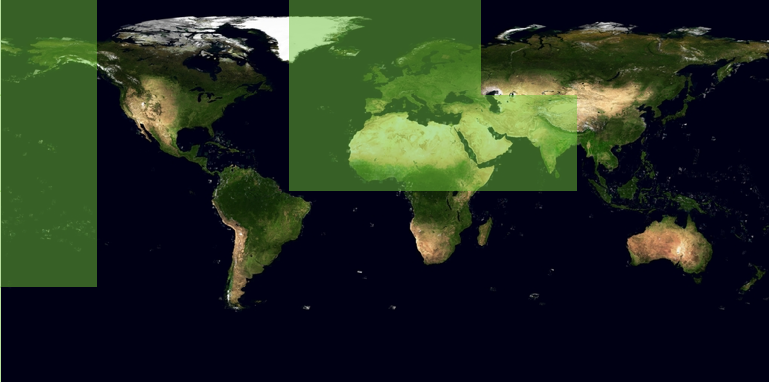
The map shows the available regions
Um die Färbungen im Lyrk Style hinzubekommen, haben wir die True Marble Satellitenbilder verwendet. Dabei handelt es sich um weltweit zusammengesetzte Landsat Bilder. Bis zu einer Auflösung von 250 Metern können diese Bilder unter CC-BY herunter geladen werden. Leider störte uns bei den Bildern die im Meer teilweise stark sichtbare Bewölkung.
Photoshop leistete hier Abhilfe. Das klingt erst mal einfach, aber bei knapp 500 Megapixel pro Datei plus Ebenenmaske kommt auch Photoshop ganz schön ins schwitzen. Neben dem Entfernen von Woken haben wir auch Inselgruppen (z.B. Spitzbergen) welche im TrueMarble Datensatz „vergessen“ wurden aus Landsat-Bildern hinzugefügt. Diese ganze Pixelschubserei war so aufwendig, dass auch nach mehreren Wochen Arbeit nur 8 der 32 Teilbilder fertig waren.
Diese 8 Bilder, die zusammen immerhin fast 4 Gigapixel umfassen, stellen wir nun als Torrent zur Verfügung. Lizenz ist weiterhin CC-BY Lyrk, Unearthed Outdoors, LLC
- Magnet Link:
magnet:?xt=urn:btih:ac33ae238ec9556a958f42236a391085b998adc1&dn=true-marble-edit%20v1&tr=udp%3A%2F%2Ftracker.ipv6tracker.org%3A80%2Fannounce&tr=http%3A%2F%2Ftracker.ipv6tracker.org%3A80%2Fannounce&tr=udp%3A%2F%2Ftracker.coppersurfer.tk%3A6969&tr=udp%3A%2F%2Ftracker.leechers-paradise.org%3A6969(sorry, GitHub erlaubt keine klickbaren Magnet Links im Markdown) - Torrent File
- Momentan sind die original True Marble Dateien nicht mehr auf unearthedoutdoors.net verfügbar. Glücklicherweise wurde die Downloadseite mit allen(?) verlinkten Dateien vom Internet Archive archiviert. Die Downloadgeschwindigkeit vom Internet Archive wird bei den großen Dateien eher langsam sein, deswegen ist es evtl. eine gute Idee diesen Torrent zu benutzen.
Die Karte zeigt die bearbeiten Bereiche