


Plugin site web: Lf Hiker
Requires Wordpress version: 4.7.3
Tested up to: Wordpress 4.9
Stable version: 1.0
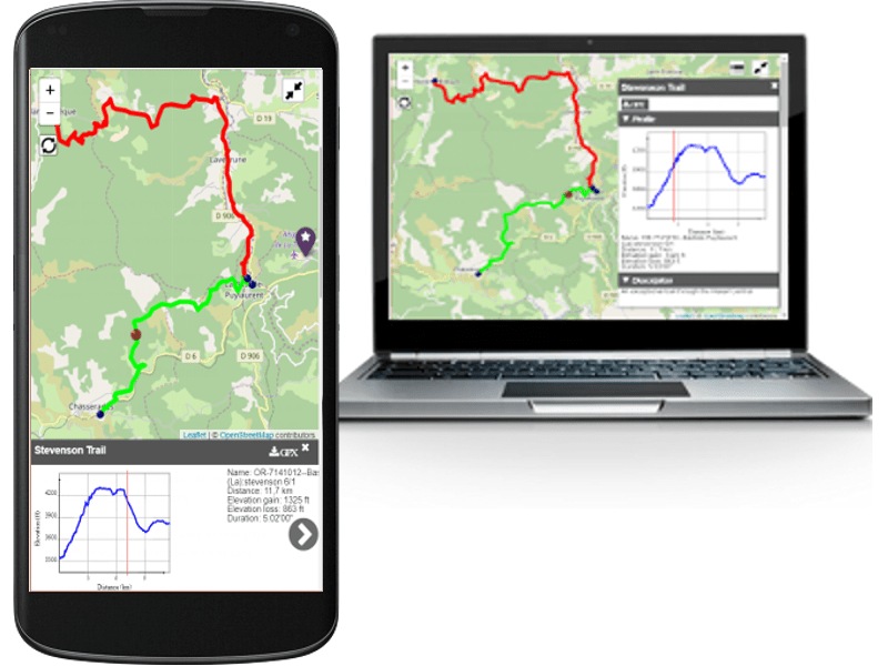
Lf Hiker is a wordpress plugin for quickly display your gpx tracks with their profile elevation on an interactive map. Lf Hiker is responsive, mobile friendly and customizable.
Simply upload your gpx file with the wordpress media manager, complete its informations and insert it in your post/page (shortcode).
Display the post/page : you have an interactive view of your track.
The trail is displayed on an OSM map by default, and have its own information window with:
- title
- description
- interactive profile elevation according to path
- distance of the track
- maximum elevation
- minimum elevation
- elevation loss
- elevation gain
- duration
- download link to gpx file
Lf Hiker allows displaying too:
- few gpx files in the same map
- markers on the map
- few maps on the same post/page
For gpx track you can custom:
- title
- description
- stroke color
- stroke width
- display button download gpx file
And only with shortcode: - the elevation unit
- the distance unit
- the minimum step on elevation axis (in meter)
Lf Hiker included an helper for edit map and add markers. You can choose
- the tiles layer ( among OSM, OSM_FR , stamen watercolor, arcgis world topo)
- fullscreen button or not
- map's view or let lf Hiker find automatically the best view
- reset button or not
- list of layers button or not
- size of the map
- classname for the map ( including your custom class)
- to zoom on mousewheel or not
- to start with profile elevation displayed
- to display the description always under the map
- color of icon marker
- symbol in the icon
- title
- popup
- visibility according to zoom or not
- independant window with formated description
You can do all this with the helpers or directly using shortcodes
You can choose to unactive the helper.
Lf Hiker allows you to customize the css in admin configuration (colors of information window, button and selected path)
For more information see Lf Hiker site
If you think you found a bug in Lf Hiker or have any problem/question concerning the plugin, do not hesitate to contact me.
- Français (fr_FR)
- English (en_US)
- Deutsch (de_DE) by Kristof Kling
- Greek (el) by Pol Gkitsas
- Dutch (nl-BE)
- Spanish (es-ES) by Miguel Angel
If you need language for Lf Hiker which is not included. You can easily translate with poedit from the file :
lf-hiker/languages/lfh-default.po.
I will be happy to add your translation to Lf Hiker.
If you have any questions about the method, do not hesitate to contact me.
If you find errors in my english translation do not hesitate to contact me.
- Wordpress 4.7.x
- PHP 5.6
- MySQL 5.x
After downloading the ZIP file lf-hiker-1.13.0.zip
- Unzip
lf-hiker.zip - Put the folder
lf-hikerin directorywp-content/plugins - Log in to the administrator panel.
- Go to Plugins Tab: Lf Hiker is among the plugins
- Click
Activatebutton for activate Lf Hiker. - If the activation does not succeed, please contact me.
Tested with
- Firefox 52.0
- Chrome 57.0
- Microsoft Edge
- Internet Explorer 11
- Safari 5 (windows)
- Opera 44
- leaflet an open-source JavaScript library for mobile-friendly interactive maps
- leaflet-gpx a leaflet plugin for the analysis and parsing of a GPX track
- font-awesome for iconic font
- awesome-marker Colorful, iconic markers by Lennard Voogdt
- Shortcode Empty Paragraph little worpress plugin fix issue shortcode by Johann Heyne
- Evolution: add spanish language
- Evolution: add empty marker
- Evolution: add dutch language
- Fixed: error twice class for label in profile svg
- Evolution: Ability to always display the caption under the map
- Evolution: Helper - Ability to add marker with its coordinates
- Evolution: Add greek translation
- Fixed: duration is not displayed
- Fixed: choose center and zoom is not working
- Fixed: lf hiker is destroying the AMP pages
- Fixed: bug with tabby-responsive-tabs plugin
- Evolution: gpx buttons are ordered in list as the gpx files in post/page
- Evolution: Ability to choose the leaflet host
- Fixed: trouble position of gpx dom block, marker block and list block
- Fixed: trouble with map when tabs (map only on top left corner)
- Evolution: Add open Topo Map tiles
- Fixed: no icon for way point
- Evolution: Add black in color path
- Evolution: Enable all hexadecimal color for path
- Evolution: Little dots at ends for path with width less than 3px
- Fixed: german translation
- Fixed: no path displayed with mesmerize theme
- Evolution: add tiles Stamen Terrain
- Evolution: add german translation
- Fixed: conflict with divi theme and option Grab the first post image
- Fixed: function boolval do not exists (version php <5.5)
- Ability to choose the default map tiles
- Display minimum elevation under profile
- Display maximum elevation under profile
- Add parameter step_min for gpx profile elevation
- Ability to choose the default step_min for elevation step in settings
- Disable map pan with one finger
- Fixed: path and marker button too high in little view
- Ability to start with profile elevation displayed
- Ability to manage (hide/show) button download gpx
- Ability to show/hide gpx path when more than 2 paths
- Ability to globally configure default settings: fullscreen, button download, start with profile displayed, add checkbox to display/hide gpx
- Fixed: some points without elevation value
- Fixed: button list always displayed when parameter list is false
- Fixed: move line on profile not visible on little screen
- fixed : issue 2 maps when the first floating the second is in stucks
- fixed : issue no icon on button
- fixed map at top (return previous version)
- fixed issue with custom field ACF dit not do shortcode
- fixed fullscreen button to false not working
- fixed display button add marker in event editor
- fixed error on activation with PHP5.5
- smooth profile when lot of points
- profile with height difference minimum 40 meters
- fixed: characters not center in buttons list and fullscreen
- modify track name filter
- fixed : too long gpx title
- fixed : url gpx with special character trigger file not found error
- disabled : map first center on Paris
- fixed : https for tiles
- fixed : gpx url for https
- fixed : On small screens, for three buttons, the elements are not centered
- fixed : Conflict with the bootstrap themes on hidden elements
- fixed : list button too big
- default value attribute visibility set to always for marker
- update modules for gulp
- add icons and create files only with used icons
- fixed : color of the buttons is applied only to the first one on the large screens
- fixed : added unwanted tag p arround shortcode
- fixed : no event on button marker when only markers elements
- fixed : helper, button add marker no event (same issue than previous)
- fixed : title height issue with some theme
- fixed : only four buttons visible on small sreens
- fixed : mousewheel disabled on element window
- fixed : issue color title h1 h2 h3 overwrite general style
- More responsive
- Mobile friendly
- More customizable
- issue map center on Paris when no title attribute in shortcode lfh-marker
- issue no map or map center on Paris conflict with AccessPress Instagram Feed
- Add foot for elevation unit
- issue for popup when click for a marker from list of elements
- Add picture for about page in back office
- Add milles distance unit for profile elevation
- issue when shortcode [lfh-map ] without attributes
- issue when no mapquest key.
- loading asynchrone js and default intialisation for the helper
- readme file
first stable version
1. How add separate map for a second gpx file in the same post
You can create a second map with adding shortcode [lfh-map] before your gpx file shortcode [lfh-gpx src="..."][/lfh-gpx].
Example:
   [lfh-map]
   [lfh-gpx src=http://url_of_gpx_file1.gpx ]description[/lfh-gpx]
   [lfh-map]
   [lfh-gpx src=http://url_of_gpx_file2.gpx ]description[/lfh-gpx]
2. Where can I create a gpx file ?
You can find a website list for do this in the page Track drawing websites
Openrunner is the best one for me and the most important: this website automatically add the elevation data needed to create the profile.
You can find on this site a quantity of already registered tracks.
You can also try the tools on www.mygpsfiles.com, easier to use
3. I have a blank page in place of the marker editor
This trouble come from conflict with multiple x-frame options directive in your server. Look at whether the plugin succeeded in writing this following lines in the .htaccess of your wordpress application if you can:
    # BEGIN Lf-hiker plugin
    <IfModule mod_headers.c>
    Header set X-Frame-Options SAMEORIGIN
    </IfModule>
    # END Lf-hiker plugin
It resolve the trouble for me.
You can find more information about this trouble in wordpress support Multiple 'X-Frame-Options' headers with conflicting values
4. The route is not displayed
If you use WP media library other than the default WP - LF Hiker will not display routes