Skip to content
New issue

Have a question about this project? Sign up for a free GitHub account to open an issue and contact its maintainers and the community.

By clicking “Sign up for GitHub”, you agree to our terms of service and privacy statement. We’ll occasionally send you account related emails.

Already on GitHub? Sign in to your account

scene coordinate system #388

Closed
HelliceSaouli opened this issue Oct 27, 2017 · 12 comments
Closed

scene coordinate system #388

HelliceSaouli opened this issue Oct 27, 2017 · 12 comments

Comments

@HelliceSaouli
Copy link

HelliceSaouli commented Oct 27, 2017

Hello
is there an easy way build in MVE to transform the point cloud of scene2pset to the scene coordinate system.
I'm developing a depth map reconstruction algorithm and feed these maps to MVE to create point cloud, I used dino dataset for testing the reconstruction is fine but it's not in scene coordinate. If I use bounding Box arg with scene2pset I get an empty ply file. otherwise, i get my points which mean my cloud is not in scene coordinate how do I fix this

note: even if I used dmrecon the same thing happen

thank you

@simonfuhrmann
Copy link
Owner

simonfuhrmann commented Oct 27, 2017

The scene2pset app exports the point cloud in the scene coordinate system. No transformations are applied. You can check by loading the point cloud and the scene in UMVE in the "Scene Inspect" tab.

@HelliceSaouli
Copy link
Author

HelliceSaouli commented Oct 27, 2017

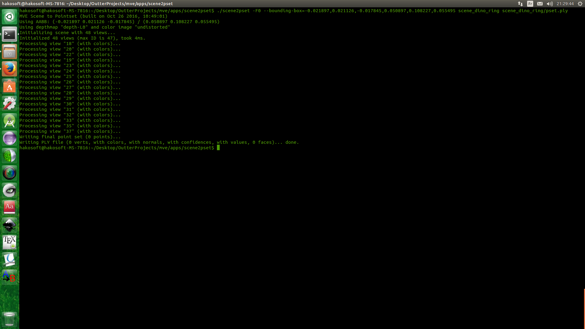
No, i don't think so. I don't have UMVE build in right now I will check later. but this is scene2pset output.
screenshot from 2017-10-27 21 29 44

this mean all point are not in BB thus they are not in scene coordinate

@simonfuhrmann
Copy link
Owner

Your bounding box, or how you specify the bounding box, must be wrong. scene2pset outputs in the scene coordinate system, that's a fact. UMVE also has a bounding box creator that can help you find the right parameters.

@HelliceSaouli
Copy link
Author

HelliceSaouli commented Oct 27, 2017

The bounding box is not mine. it is actually from vision.Middelburry, and the reason i bring this up is that i sent my result for evaluation to Middlebury and they said my points are not in the correct coordinate and they asked me to run sanity check using their bounding box and the image above is the result.
Also according to your answer for issue 358 : " All results are in the coordinate system dictated by SfM. If you want a specific scene coordinate system, you have to transform it yourself". the points are not in scene coordinate system

@simonfuhrmann
Copy link
Owner

Are you running SfM on the Middleburry datasets? This will basically create an arbitrary scene coordinate system that has nothing to do with the one Middleburry expects. If you want to do this properly, this is what you have to do:

  1. Use the camera intrinsics and extrinsics as specified in the Middleburry dataset, and use that for the views, i.e., insert the parameters into the meta.ini files.
  2. Create SfM features without actually running SfM. That's the tricky part, because you want to detect, match, triangulate features, and then run an optimization that doesn't change the camera parameters. I don't think we have code for this exact scenario right now.
  3. Run your code on the resulting scene, which is in the Middleburry corrdinate system.

@HelliceSaouli
Copy link
Author

HelliceSaouli commented Oct 27, 2017

oh ok, it weird and I don't see the logic behind this XD. I will do what you said, but step 2 is going to be hard -__-

@HelliceSaouli
Copy link
Author

last question and i will go to sleep x') : if I run sfmrecon with this 2 arg = true

  1. args.add_option('\0', "fixed-intrinsics", false, "Do not optimize camera intrinsics");
  2. args.add_option('\0', "shared-intrinsics", false, "Share intrinsics between all cameras");

will it work?

@simonfuhrmann
Copy link
Owner

simonfuhrmann commented Oct 27, 2017

No. Because you'll also have to fix the extrinsics. And fixing the extrinsics is not supported by nature of the incremental SfM approach.

What's weird about these steps? Step 1 should be fairly self-explanatory, you have to use the Middleburry provided parameters as these "ground truth" camera parameters are better than what any SfM can produce. Step 2 is required because our MVS requires SfM points to work. If you have a MVS algorithm that doesn't require SfM points, you can probably omit this step.

@HelliceSaouli
Copy link
Author

Thank you for all the answers you provided. it is really helpful.
It is not the steps that are weird. but why sfm parameters are way off from the ground truth. and no I can't omit the 2end step since my work is based on your work a specially dmrecon , I also use features as seed to estimate depth and normals. This is why I'm posting a lot of issues and asking so many question ^__^

@simonfuhrmann
Copy link
Owner

The SfM reconstruction has a 7 dimensional ambiguity, that is position, orientation and scale with respect to the original real world object. This ambiguity is resolved in the first SfM steps by making some arbitrary decisions.

So the reconstruction is not "way off", just different with respect to this ambiguity.

@simonfuhrmann
Copy link
Owner

I added a simple tool that does what you want. Please read this page.
https://github.com/simonfuhrmann/mve/wiki/Middlebury-Datasets

@HelliceSaouli
Copy link
Author

Thank you so much ,

Sign up for free to join this conversation on GitHub. Already have an account? Sign in to comment
Labels
None yet
Projects
None yet
Development

No branches or pull requests

2 participants