cycleway with a foot=designated and footway with a bicycle=designated distinction seems useless #575
Comments
|
As discussed in #397 I agree with you, but @Florimondable has disagreed in #397 (comment) Since this disagreement was lacking of explanations, and the topic is coming back, let’s discuss this point again. I’m still convinced it would be a more coherent view of osm data. |
|
Oh, thanks, didn't notice this issue, since the title was about something different. I too think that it's more important to document legally verifiable truth than what some mappers in France feel. I don't even cycle in France. And it's better to support all tagging schemes users everywhere actually use instead of trying to encourage to map for the render. Footways, cycleways, tracks should be rendered similarly, by checking who they are designated for, with footway and cycleway having defaults. Edit: Edit2: Also, I'm not quite sure with what exactly @Florimondable disagreed with. |
|
If you have a cycleway why we should taking care of having pedestrian allowed or not ? This is a cycle map. If there is lot of pedestrian on a cycleway, may be it shouldn’t be tagged as a cycleway but as a shared path. Real world examples are welcome. |
This may be your personal preference but it’s not something we may take for granted. Did you read https://wiki.openstreetmap.org/wiki/Path_controversy ? |
|
@Florimondable because highway=cycleway with foot=designated is a perfectly valid tagging. The real world example is the road sign I posted in the first comment and it can be tagged differently. And all valid tagging schemes should taken into account. There is no way a mapper can easily and objectively measure how many pedestrians use the shared path, especially considering that it changes with time. Cycleway and footway tags don't say anything about how many cyclists/pedestrians use the path. What you want the highway=cycleway tag to be does not align with what it is. Since it is a cycle map I think cyclists would benefit from knowing if pedestrians are to be expected on a highway=cycleway. |
If I'm not mistaking, this is case S7 in https://wiki.openstreetmap.org/wiki/Bicycle which indeed is a valid tagging scheme worldwide. Note that this is however different than the "segregated" tagging scheme which is S5 in https://wiki.openstreetmap.org/wiki/Bicycle and explicitly direct to use EDIT:
Sure, but I'm not sure we should be trying to guess what the infrastructure actually is, beyond standardized tagging schemes: So, TLDR, of course, I am in favor of rendering everything as it is expected from the tagging description, as long as the scheme is somehow standardized (or can be considered as such due to a wide use locally). |
|
By the way, could we try to limit the number of similar issues. The discussion here seems to cross the one in #397 on a number of subjects. Could we try to sum up the main concerns here and if #397 and this one are indeed about the same concern, merge the discussion in a single thread? Thanks! EDIT: See as well #450. |
yes
That’s not a real world example, it’s just a board, anyhow this board doesn’t describe a cycleway but a path.
There are ways to measure that.
Pedestrian is always being expected on cycleway, the question is how many. If I remembre well the choice of not taking care of foot=designated on cycleway is that if it’s a cycleway it’s cycleway state is more important than knowing that maybe there are pedestrian on it. |
About segregated: in addition we have this https://wiki.openstreetmap.org/wiki/Tag:highway%3Dcycleway where it doesn't prohibit tagging foot access and segregation. Also, in ID editor template for the combined foot and bicycle access is based on a cycleway. So not only we have already a lot of combined ways mapped as cycleway + foot=designated, this is encouraged by the editor and will continue to be added. Same goes for StreetComplete, if it sees a cycleway with foot access, then it asks if it's segregated and doesn't care about changing it into a path or a footway. So I'd say we have to live with that the data in OSM is and will be like this for a while.
There is a branch currently and I'm arguing that it is useless in a lot of places and depends on a personal opinion of someone on what is a cycleway. The idea is to change this branch's condition. I haven't looked at the query, but are you sure this will be a big performance hit compared to all the other things which are done to render something? It's just that I think it is a good feature for a map which focuses on cycling. Currently for me the map is colored in random blue shades and all I know is that somewhere in France they may mean something. Think of the end user who doesn't know about tags at all, he'd be confused why some combined ways are lighter and some are darker.
There are no valid schemes, but there is an actual state of how the data is and how it will be. I don't think there is a point of going against something this big, you won't win. You think this is a path, someone thinks this is a cycleway with foot=designated, then someone else thinks it's a footway with bicycle=designated. Tagging could be better, obviously, as mentioned in "path controversy", but there are no changes on the horizon and if there were, they would be backwards-compatible. The point is, all those different tagging schemes document the same thing and it should be drawn the same. As such this
is a personal opinion. I'd like it to be like that, but it's not and it's not really encouraged by the wiki.
In Estonia it's forbidden to walk on a cycleway and while some do walk, there is usually a footway in parallel where most people walk. Don't know about France, but I've heard they are very strict with rules like this in Netherlands.
Yes, but they require a lot of organization, maybe from government, or a lot of time from mappers. This is not something which can be achieved in short time and to be expected by default for every way. It would definitely also require separate tags (not like there would be some threshold by which we decide if it's a cycleway or a path). If we could have this data for most places, this would be awesome and I'd say it would be more important than seeing if the cycleway is combined with a pedestrian path. But unfortunately, this is not possible in near future for most of paths. |
Real world example here : https://www.google.fr/maps/@59.450609,24.8606561,3a,75y,2.13h,79.89t/data=!3m6!1e1!3m4!1sYwzbchIZ_RZ3_F5U4AKYNA!2e0!7i13312!8i6656 I don’t understand how this can be map as a highway=cycleway, it’s a shared path by design and defined by the board. So for me this is just mistagging and could be fixed. |
|
This is exactly what we say, « for you » it’s wrong. JOSM tags your example as a path, you’re not alone :-) But many mappers think Both tagging styles coexist, we don’t understand why you assume second one is bad tagging. It’s not even a French preference (may be Paris only?) I can find many « voies vertes » tagged as cycleway if you want. If for some reason I missed that |
|
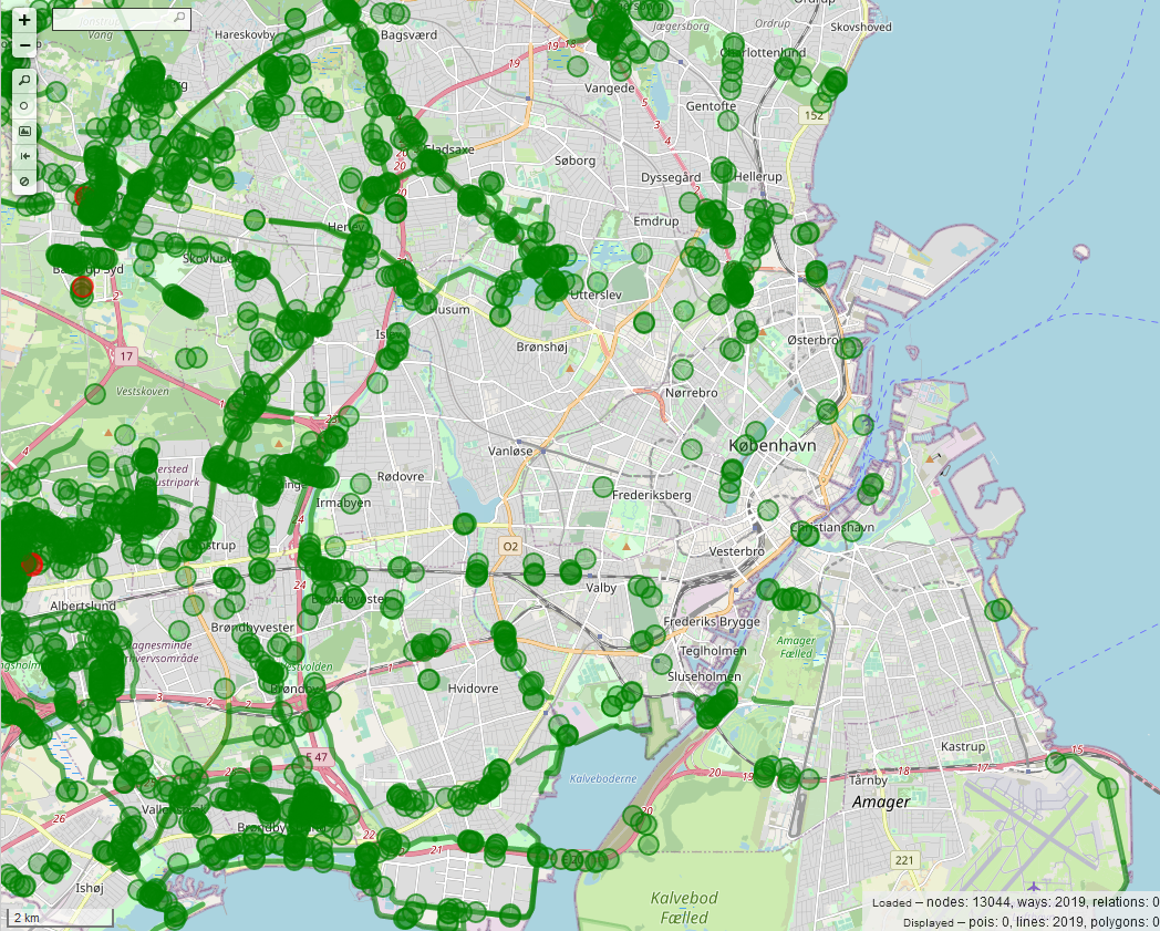
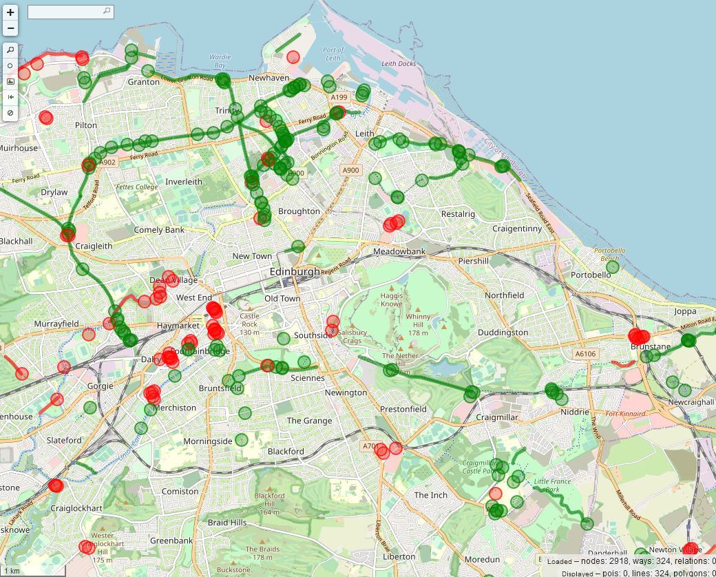
Here are some examples that this tagging of combined ways as a cycleway is actually used (the green ones are cycleways with foot=designated): Copenhagen Stockholm Edinburgh |

|
Ummm you don't really prove anything by those examples. I don't know what to say. Some are bad tagging, but not all. Others are bad tagging in your personal opinion. |
|
Are you saying that:
Or is there a misunderstanding ? |
|
Many people may say that 2 and 2 make 5, that's not a reason I'll accept it. highway=cycleway is for bicycle only way not for shared path. You're free to fix tags of the shared paths in your area. |
|
Tagging for the renderer is considered bad. Even if it is a change from one valid scheme to another valid scheme, I don't think that it should be done. |
|
I'm jumping in into this thread. First of all, regarding the performance argument
I was just saying that CyclOSM now operates on a quite large scale, with comparatively quite small servers. I did not investigate the performance issue here, and in any case performance considerations should not be an obstacle to proper rendering according to OSM guidelines, it should only be taken into account when taking extra steps to further guess / improve tagging when it is lacking details. Regarding the overall issue and the specific point of
I do not see any edit wars or specific discussion in the before mentionned wiki pages concerning this Note: Note that the situation is very much different in France (and hence, in the Note 2: The German wiki (German community being one of the most active I know about when dealing with bicycle tagging) seems to have an extensive section on the matter: https://wiki.openstreetmap.org/wiki/DE:Bicycle/Meinungsstreit_Radverkehrsanlagen. I'm not a German speaker, so I'll welcome feedbacks from German speakers, but Google automated translation seems pretty good here https://translate.google.com/translate?hl=&sl=de&tl=en&u=https%3A%2F%2Fwiki.openstreetmap.org%2Fwiki%2FDE%3ABicycle%2FMeinungsstreit_Radverkehrsanlagen. All of this being said, I am convinced Before having a deep dive into the code, and in particular PR #450, is there any other points (beyond the previous equivalence) that should be addressed as part of this issue (#575) or its sister issue #397? |
|
Just adding that I support this change. The Australian tagging guidelines on the wiki say to tag shared paths as Due to most mappers in my city following this guideline, with the current CyclOSM style, it is impossible to tell the difference between shared paths vs. dedicated cycleways, and plan my route to prefer the latter where possible. Using the light blue colour for |
Cycleways can have a foot=designated tag, but still they will be rendered with a darker blue than a footway with a bicycle=designated. Both of those cases are used for paths like this:

As a result this color distinction does not help at all, only says how the way was initially mapped.
https://www.cyclosm.org/#map=18/59.43344/24.81383/cyclosm
I'd propose to use darker blue only for a bicycle-only paths with a foot=no or empty. And lighter blue for combined paths, both for a cycleway with foot=designated and a footway with a bicycle=designated.
I understand that countries with good bicycle infrastructure have many bicycle only roads and don't have many roads with combined use and maybe this rendering problem is not noticed, but this is not the case in my country. Most of the roads which cyclists are expected to use are also footpaths. And some map them as a cycleway, others as a footpath resulting in color difference which gives no information. Or maybe there is a case in some country where current rendering does have a meaningful information?
The text was updated successfully, but these errors were encountered: